|
|
|
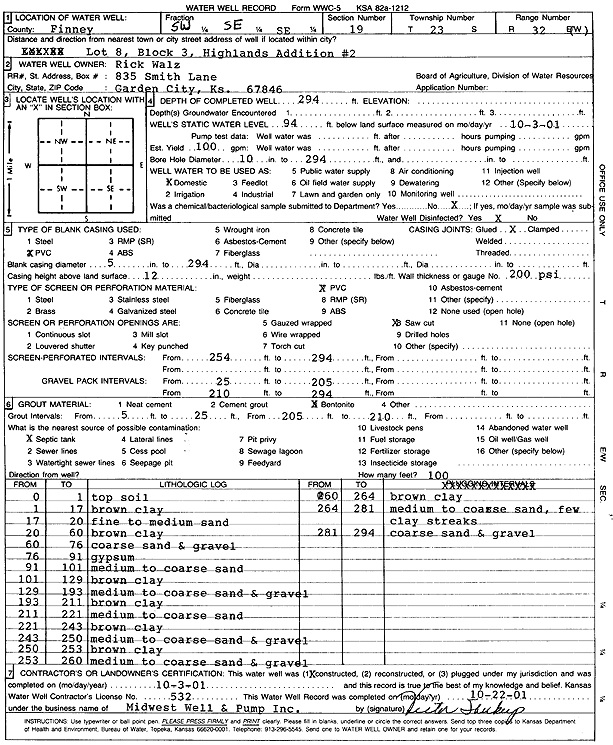
Specific Water Well Detail |
|
|
| Location Info | |||
| Owner: Walz, Rick | Status: Constructed | ||
| Location: T23S, R32W, Sec. 19, SW SE SE | County: Finney | ||
| Directions: Lot 8, Block 3, Highlands Addition 2 | |||
| Latitude: 38.0338333 | Longitude: -100.8687759 | Datum NAD 27 | |
| Latitude: 38.0338562 | Longitude: -100.8692143 | Datum NAD 83 | |
| Longitude and latitude calculated by Survey from township-range-section-quarter calls. Only good to within the quarter call accuracy. | |||
| View well on interactive map | |||
| General Info | ||
| Well Depth: 294 ft. | Elevation: ft. | |
| Static Water Level: 94 ft. | Est. Yield: 100 gpm. | |
| Comp. Date: 03-Oct-2001 | Well Use: Domestic | |
| DWR Applic. #: | Other ID: | |
| Driller Info | ||
| Driller: Midwest Well & Pump, Inc. | License #: 532 | |
| Scanned Form | View scan |
|
Chemical Sample Submitted?:
Water Well disinfected?: | ||
| Casing Info | ||
| Casing Type:
Casing Joints: |
Diam: in. to ft | |
| Casing height above land surface: in
Casing Weight: lbs/ft Wall thickness or gauge no.: | ||
| Screen and Perforation Info | ||
| Screen Type: | Screen Openings: | |
| Screen-perforated intervals | From: ft to ft | |
| Gravel pack intervals | From: ft to ft | |
| Grout Info | ||
| Grout used: | From: to ft | |
| Source of Possible Contamination | ||
| Source: | ||
| Direction from well: | Distance: ft | |
| Lithologic Log
(Log data entered by KGS.) | ||
| From: 0 ft. to 1 ft. | top soil | |
| From: 1 ft. to 17 ft. | brown clay | |
| From: 17 ft. to 20 ft. | fine to medium sand | |
| From: 20 ft. to 60 ft. | brown clay | |
| From: 60 ft. to 76 ft. | coarse sand and gravel | |
| From: 76 ft. to 91 ft. | gypsum | |
| From: 91 ft. to 101 ft. | medium to coarse sand | |
| From: 101 ft. to 129 ft. | brown clay | |
| From: 129 ft. to 193 ft. | medium to coarse sand and gravel | |
| From: 193 ft. to 211 ft. | brown clay | |
| From: 211 ft. to 221 ft. | medium to coarse sand | |
| From: 221 ft. to 243 ft. | brown clay | |
| From: 243 ft. to 250 ft. | medium to coarse sand and gravel | |
| From: 250 ft. to 253 ft. | brown clay | |
| From: 253 ft. to 260 ft. | medium to coarse sand and gravel | |
| From: 260 ft. to 264 ft. | brown clay | |
| From: 264 ft. to 281 ft. | medium to coarse sand, few clay streaks | |
| From: 281 ft. to 294 ft. | coarse sand and gravel | |