|
|
|
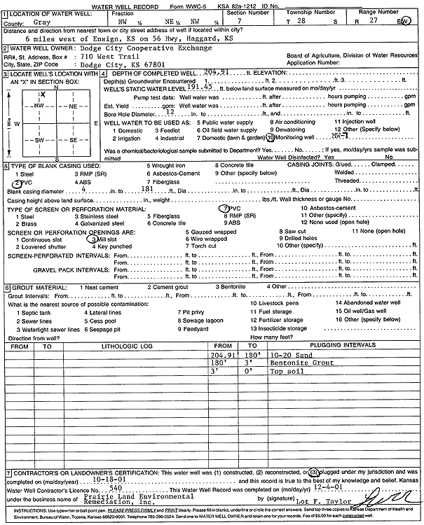
Specific Water Well Detail |
|
|
| Location Info | |||
| Owner: Dodge City Co-op | Status: Plugged | ||
| Location: T28S, R27W, Sec. 7, NW NE NW | County: Gray | ||
| Directions: from Ensign: 6 mi W on Hwy 56 | |||
| Latitude: 37.6345174 | Longitude: -100.3186018 | Datum NAD 27 | |
| Latitude: 37.6345399 | Longitude: -100.3190243 | Datum NAD 83 | |
| Longitude and latitude calculated by Survey from township-range-section-quarter calls. Only good to within the quarter call accuracy. | |||
| View well on interactive map | |||
| General Info | ||
| Well Depth: 204.9 ft. | Elevation: ft. | |
| Static Water Level: 191.5 ft. | Est. Yield: gpm. | |
| Comp. Date: 18-Oct-2001 | Well Use: Monitoring well/observation/piezometer | |
| DWR Applic. #: | Other ID: MW 7 | |
| Driller Info | ||
| Driller: Prairie Land Environmental Remed. | License #: 540 | |
| Scanned Form | View scan |
| Casing Info | ||
|
Casing Type:
Diam: in. Casing height above land surface: in | ||
| Grout Info | ||
| Grout used: | From: to ft | |
| Source of Possible Contamination | ||
| Source: | ||
| Direction from well: | Distance: ft | |