|
|
|
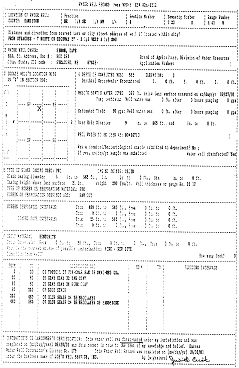
Specific Water Well Detail |
|
|
| Location Info | |||
| Owner: Simon, Dave | Status: Constructed | ||
| Location: T23S, R41W, Sec. 4, NE SE NW | County: Hamilton | ||
| Directions: from Syracuse: 7 mi N on Hwy 27, 3.5 mi W, .5 mi S | |||
| Latitude: 38.0835681 | Longitude: -101.8269728 | Datum NAD 27 | |
| Latitude: 38.0835821 | Longitude: -101.827425 | Datum NAD 83 | |
| Longitude and latitude calculated by Survey from township-range-section-quarter calls. Only good to within the quarter call accuracy. | |||
| View well on interactive map | |||
| General Info | ||
| Well Depth: 565 ft. | Elevation: ft. | |
| Static Water Level: 326 ft. | Est. Yield: 30 gpm. | |
| Comp. Date: 28-Sep-2001 | Well Use: Domestic | |
| DWR Applic. #: | Other ID: | |
| Driller Info | ||
| Driller: Joe's Well Service, Inc. | License #: 179 | |
| Scanned Form | View scan |
|
Chemical Sample Submitted?:
Water Well disinfected?: | ||
| Casing Info | ||
| Casing Type:
Casing Joints: |
Diam: in. to ft | |
| Casing height above land surface: in
Casing Weight: lbs/ft Wall thickness or gauge no.: | ||
| Screen and Perforation Info | ||
| Screen Type: | Screen Openings: | |
| Screen-perforated intervals | From: ft to ft | |
| Gravel pack intervals | From: ft to ft | |
| Grout Info | ||
| Grout used: | From: to ft | |
| Source of Possible Contamination | ||
| Source: | ||
| Direction from well: | Distance: ft | |
| Lithologic Log
(Log data entered by KGS.) | ||
| From: 0 ft. to 20 ft. | top soil, fine-coarse sand, small-medium gravel | |
| From: 20 ft. to 60 ft. | gray and tan clay | |
| From: 60 ft. to 80 ft. | gray and blue clay | |
| From: 80 ft. to 220 ft. | blue shale | |
| From: 220 ft. to 450 ft. | blue shale, thin rock layer | |
| From: 450 ft. to 560 ft. | blue shale, thin rock layer, and sandstone | |