|
|
|
Specific Water Well Detail |
|
|
| Location Info | |||
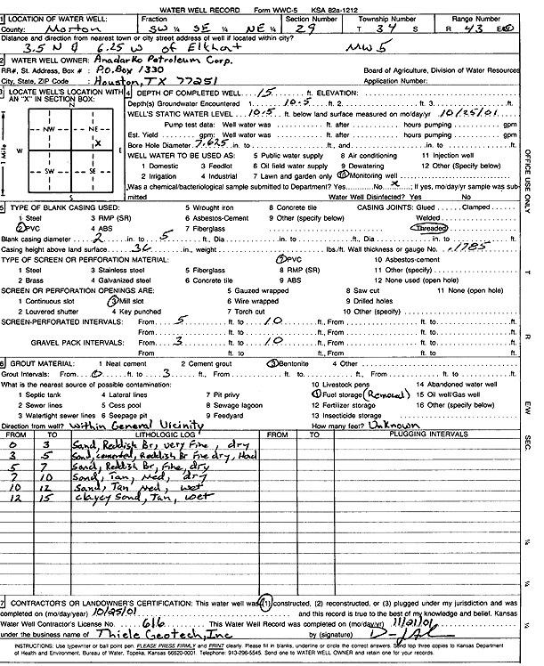
| Owner: Anadarko Petroleum Corp. | Status: Constructed | ||
| Location: T34S, R43W, Sec. 29, SW SE NE | County: Morton | ||
| Directions: from Elkhart: 3.5 mi N, 6.25 mi W | |||
| Latitude: 37.0620083 | Longitude: -102.0108504 | Datum NAD 27 | |
| Latitude: 37.0620305 | Longitude: -102.0112991 | Datum NAD 83 | |
| Longitude and latitude calculated by Survey from township-range-section-quarter calls. Only good to within the quarter call accuracy. | |||
| View well on interactive map | |||
| General Info | ||
| Well Depth: 15 ft. | Elevation: ft. | |
| Static Water Level: 10.5 ft. | Est. Yield: gpm. | |
| Comp. Date: 25-Oct-2001 | Well Use: Monitoring well/observation/piezometer | |
| DWR Applic. #: | Other ID: MW 5 | |
| Driller Info | ||
| Driller: Dennis J. Anderson, Thiele Geotech, Inc. | License #: 616 | |
| Scanned Form | View scan |
|
Chemical Sample Submitted?:
Water Well disinfected?: | ||
| Casing Info | ||
| Casing Type:
Casing Joints: |
Diam: in. to ft | |
| Casing height above land surface: in
Casing Weight: lbs/ft Wall thickness or gauge no.: | ||
| Screen and Perforation Info | ||
| Screen Type: | Screen Openings: | |
| Screen-perforated intervals | From: ft to ft | |
| Gravel pack intervals | From: ft to ft | |
| Grout Info | ||
| Grout used: | From: to ft | |
| Source of Possible Contamination | ||
| Source: | ||
| Direction from well: | Distance: ft | |
| Lithologic Log
(Log data entered by KGS.) | ||
| From: 0 ft. to 3 ft. | sand, reddish brown, very fine, dry | |
| From: 3 ft. to 5 ft. | sand, cemented, reddish brown, fine, dry, hard | |
| From: 5 ft. to 7 ft. | sand, reddish brown, fine, dry | |
| From: 7 ft. to 10 ft. | sand, tan, med, dry | |
| From: 10 ft. to 12 ft. | sand, tan med, wet | |
| From: 12 ft. to 15 ft. | clayey sand, tan, wet | |