|
|
|
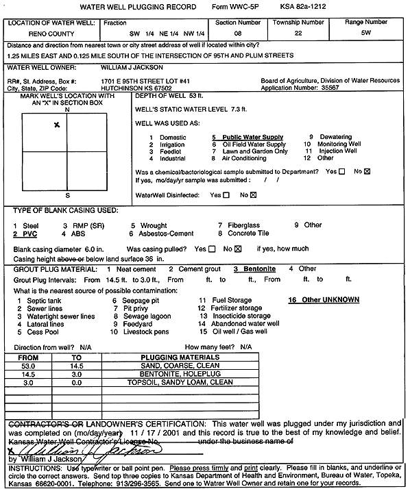
Specific Water Well Detail |
|
|
| Location Info | |||
| Owner: Jackson, William J. | Status: Plugged | ||
| Location: T22S, R5W, Sec. 8, SW NE NW | County: Reno | ||
| Directions: from 95th and Plum, Hutchinson: 1.25 mi E, .13 mi S | |||
| Latitude: 38.1565564 | Longitude: -97.8978234 | Datum NAD 27 | |
| Latitude: 38.1565668 | Longitude: -97.8981521 | Datum NAD 83 | |
| Longitude and latitude calculated by Survey from township-range-section-quarter calls. Only good to within the quarter call accuracy. | |||
| View well on interactive map | |||
| General Info | ||
| Well Depth: 53 ft. | Elevation: ft. | |
| Static Water Level: 7.3 ft. | Est. Yield: gpm. | |
| Comp. Date: 17-Nov-2001 | Well Use: Public Water Supply | |
| DWR Applic. #: | Other ID: | |
| Driller Info | ||
| Driller: William J. Jackson | License #: | |
| Scanned Form | View scan |
| Casing Info | ||
|
Casing Type:
Diam: in. Casing height above land surface: in | ||
| Grout Info | ||
| Grout used: | From: to ft | |
| Source of Possible Contamination | ||
| Source: | ||
| Direction from well: | Distance: ft | |