|
|
|
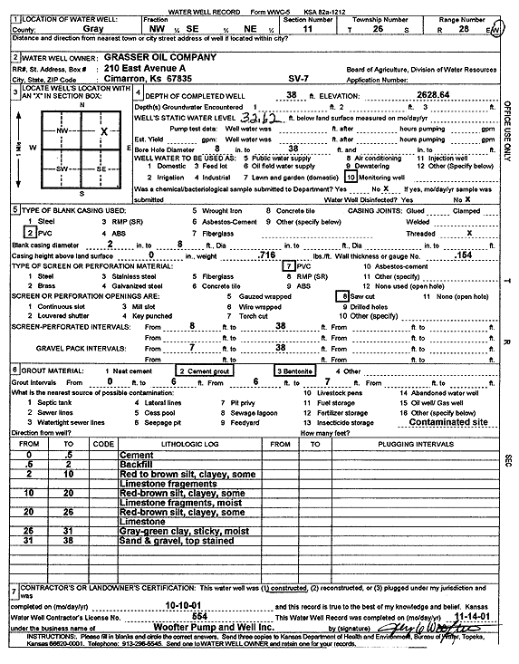
Specific Water Well Detail |
|
|
| Location Info | |||
| Owner: Grasser Oil Co. | Status: Constructed | ||
| Location: T26S, R28W, Sec. 11, NW SE NE | County: Gray | ||
| Directions: | |||
| Latitude: 37.8055112 | Longitude: -100.3453001 | Datum NAD 27 | |
| Latitude: 37.8055327 | Longitude: -100.3457226 | Datum NAD 83 | |
| Longitude and latitude calculated by Survey from township-range-section-quarter calls. Only good to within the quarter call accuracy. | |||
| View well on interactive map | |||
| General Info | ||
| Well Depth: 38 ft. | Elevation: 2628.64 ft. | |
| Static Water Level: 32.62 ft. | Est. Yield: gpm. | |
| Comp. Date: 10-Oct-2001 | Well Use: Monitoring well/observation/piezometer | |
| DWR Applic. #: | Other ID: SV 7 | |
| Driller Info | ||
| Driller: Jay C. Woofter Pump & Well, Inc. | License #: 554 | |
| Scanned Form | View scan |
|
Chemical Sample Submitted?:
Water Well disinfected?: | ||
| Casing Info | ||
| Casing Type:
Casing Joints: |
Diam: in. to ft | |
| Casing height above land surface: in
Casing Weight: lbs/ft Wall thickness or gauge no.: | ||
| Screen and Perforation Info | ||
| Screen Type: | Screen Openings: | |
| Screen-perforated intervals | From: ft to ft | |
| Gravel pack intervals | From: ft to ft | |
| Grout Info | ||
| Grout used: | From: to ft | |
| Source of Possible Contamination | ||
| Source: | ||
| Direction from well: | Distance: ft | |
| Lithologic Log
(Log data entered by KGS.) | ||
| From: 0 ft. to .5 ft. | Cement | |
| From: .5 ft. to 2 ft. | Backfill | |
| From: 2 ft. to 10 ft. | Red to brown silt, clayey, some Limestone fragments | |
| From: 10 ft. to 20 ft. | Red-brown silt, clayey, some Limestone fragments, moist | |
| From: 20 ft. to 26 ft. | Red-brown silt, clayey, some Limestone | |
| From: 26 ft. to 31 ft. | Gray-green clay, sticky, moist | |
| From: 31 ft. to 38 ft. | Sand and gravel, top stained | |