|
|
|
Specific Water Well Detail |
|
|
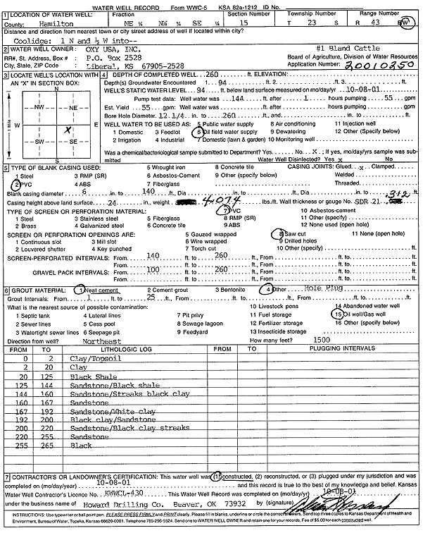
| Location Info | |||
| Owner: Oxy USA, Inc. | Status: Constructed | ||
| Location: T23S, R43W, Sec. 15, NE NW SE | County: Hamilton | ||
| Directions: from Coolidge: 1 mi N, .5 mi W into site | |||
| Latitude: 38.0507825 | Longitude: -102.023477 | Datum NAD 27 | |
| Latitude: 38.0507956 | Longitude: -102.0239369 | Datum NAD 83 | |
| Longitude and latitude calculated by Survey from township-range-section-quarter calls. Only good to within the quarter call accuracy. | |||
| View well on interactive map | |||
| General Info | ||
| Well Depth: 260 ft. | Elevation: ft. | |
| Static Water Level: 94 ft. | Est. Yield: 55 gpm. | |
| Comp. Date: 08-Oct-2001 | Well Use: Oil Field Water Supply | |
| DWR Applic. #: 20010250 | Other ID: Bland Cattle 1 | |
| Links | |
| No Wizard information available. | |
| View info from WIMAS Water Right Data base... | |
| Driller Info | ||
| Driller: Howard Drilling Company AG, LLC | License #: 430 | |
| Scanned Form | View scan |
|
Chemical Sample Submitted?:
Water Well disinfected?: | ||
| Casing Info | ||
| Casing Type:
Casing Joints: |
Diam: in. to ft | |
| Casing height above land surface: in
Casing Weight: lbs/ft Wall thickness or gauge no.: | ||
| Screen and Perforation Info | ||
| Screen Type: | Screen Openings: | |
| Screen-perforated intervals | From: ft to ft | |
| Gravel pack intervals | From: ft to ft | |
| Grout Info | ||
| Grout used: | From: to ft | |
| Source of Possible Contamination | ||
| Source: | ||
| Direction from well: | Distance: ft | |
| Lithologic Log
(Log data entered by KGS.) | ||
| From: 0 ft. to 2 ft. | clay/topsoil | |
| From: 2 ft. to 20 ft. | clay | |
| From: 20 ft. to 125 ft. | black shale | |
| From: 125 ft. to 144 ft. | sandstone/black shale | |
| From: 144 ft. to 160 ft. | sandstone/streaks black clay | |
| From: 160 ft. to 167 ft. | sandstone | |
| From: 167 ft. to 192 ft. | sandstone/white clay | |
| From: 192 ft. to 200 ft. | black clay/sandstone | |
| From: 200 ft. to 220 ft. | sandstone/black clay streaks | |
| From: 220 ft. to 255 ft. | sandstone | |
| From: 255 ft. to 265 ft. | black | |