|
|
|
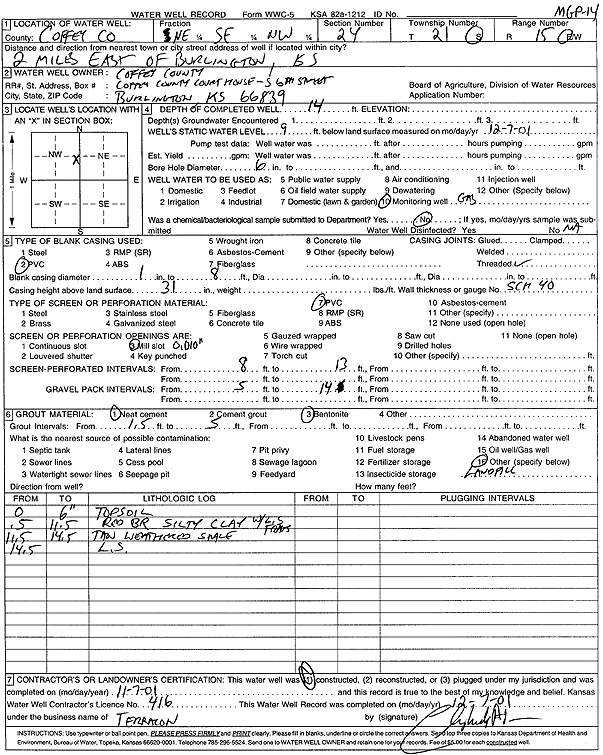
Specific Water Well Detail |
|
|
| Location Info | |||
| Owner: Coffey County | Status: Constructed | ||
| Location: T21S, R15E, Sec. 24, NE SE NW | County: Coffey | ||
| Directions: from Burlington: 2 mi E | |||
| Latitude: 38.2090297 | Longitude: -95.7118704 | Datum NAD 27 | |
| Latitude: 38.2090515 | Longitude: -95.7121342 | Datum NAD 83 | |
| Longitude and latitude calculated by Survey from township-range-section-quarter calls. Only good to within the quarter call accuracy. | |||
| View well on interactive map | |||
| General Info | ||
| Well Depth: 14 ft. | Elevation: ft. | |
| Static Water Level: 9 ft. | Est. Yield: gpm. | |
| Comp. Date: 07-Nov-2001 | Well Use: Monitoring well/observation/piezometer | |
| DWR Applic. #: | Other ID: MGP 14 | |
| Driller Info | ||
| Driller: Terracon Consultants, Inc. | License #: 416 | |
| Scanned Form | View scan |
|
Chemical Sample Submitted?:
Water Well disinfected?: | ||
| Casing Info | ||
| Casing Type:
Casing Joints: |
Diam: in. to ft | |
| Casing height above land surface: in
Casing Weight: lbs/ft Wall thickness or gauge no.: | ||
| Screen and Perforation Info | ||
| Screen Type: | Screen Openings: | |
| Screen-perforated intervals | From: ft to ft | |
| Gravel pack intervals | From: ft to ft | |
| Grout Info | ||
| Grout used: | From: to ft | |
| Source of Possible Contamination | ||
| Source: | ||
| Direction from well: | Distance: ft | |
| Lithologic Log
(Log data entered by KGS.) | ||
| From: 0 ft. to .5 ft. | top soil | |
| From: .5 ft. to 11.5 ft. | red brown silty clay with limestone fragments | |
| From: 11.5 ft. to 14.5 ft. | tan weathered shale | |
| From: 14.5 ft. to ft. | limestone | |