|
|
|
Specific Water Well Detail |
|
|
| Location Info | |||
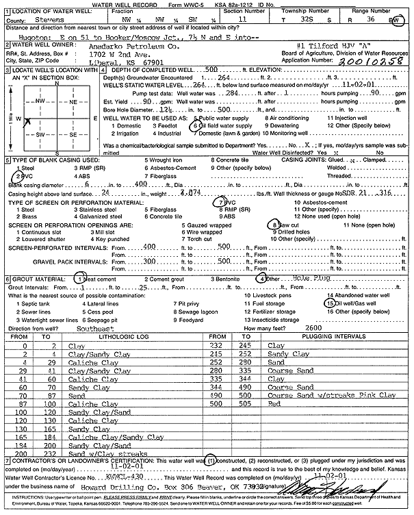
| Owner: Anadarko Petroleum Corp. | Status: Constructed | ||
| Location: T32S, R36W, Sec. 11, NW NW SW | County: Stevens | ||
| Directions: from Hugoton: E on 51 to Hooker/Moscow Jct, 7.5 mi N, E into site | |||
| Latitude: 37.2777686 | Longitude: -101.2109997 | Datum NAD 27 | |
| Latitude: 37.2777925 | Longitude: -101.211436 | Datum NAD 83 | |
| Longitude and latitude calculated by Survey from township-range-section-quarter calls. Only good to within the quarter call accuracy. | |||
| View well on interactive map | |||
| General Info | ||
| Well Depth: 500 ft. | Elevation: ft. | |
| Static Water Level: 264 ft. | Est. Yield: 90 gpm. | |
| Comp. Date: 02-Nov-2001 | Well Use: Oil Field Water Supply | |
| DWR Applic. #: 20010258 | Other ID: HJV Tilford A-1 | |
| Links | |
| No Wizard information available. | |
| View info from WIMAS Water Right Data base... | |
| Driller Info | ||
| Driller: Howard Drilling Company AG, LLC | License #: 430 | |
| Scanned Form | View scan |
|
Chemical Sample Submitted?:
Water Well disinfected?: | ||
| Casing Info | ||
| Casing Type:
Casing Joints: |
Diam: in. to ft | |
| Casing height above land surface: in
Casing Weight: lbs/ft Wall thickness or gauge no.: | ||
| Screen and Perforation Info | ||
| Screen Type: | Screen Openings: | |
| Screen-perforated intervals | From: ft to ft | |
| Gravel pack intervals | From: ft to ft | |
| Grout Info | ||
| Grout used: | From: to ft | |
| Source of Possible Contamination | ||
| Source: | ||
| Direction from well: | Distance: ft | |
| Lithologic Log
(Log data entered by KGS.) | ||
| From: 0 ft. to 2 ft. | clay | |
| From: 2 ft. to 4 ft. | clay/sandy clay | |
| From: 4 ft. to 29 ft. | caliche clay | |
| From: 29 ft. to 41 ft. | clay/sandy clay | |
| From: 41 ft. to 60 ft. | caliche clay | |
| From: 60 ft. to 70 ft. | sandy clay | |
| From: 70 ft. to 87 ft. | sand | |
| From: 87 ft. to 100 ft. | caliche clay | |
| From: 100 ft. to 120 ft. | sandy clay/sand | |
| From: 120 ft. to 130 ft. | caliche clay | |
| From: 130 ft. to 165 ft. | sandy clay | |
| From: 165 ft. to 184 ft. | caliche clay/sandy clay | |
| From: 184 ft. to 200 ft. | sandy clay/sand | |
| From: 200 ft. to 232 ft. | sand with clay streaks | |
| From: 232 ft. to 245 ft. | clay | |
| From: 245 ft. to 252 ft. | sandy clay | |
| From: 252 ft. to 280 ft. | sand | |
| From: 280 ft. to 335 ft. | coarse sand | |
| From: 335 ft. to 344 ft. | clay | |
| From: 344 ft. to 490 ft. | coarse sand | |
| From: 490 ft. to 500 ft. | coarse sand with streaks pink clay | |
| From: 500 ft. to 505 ft. | red | |