|
|
|
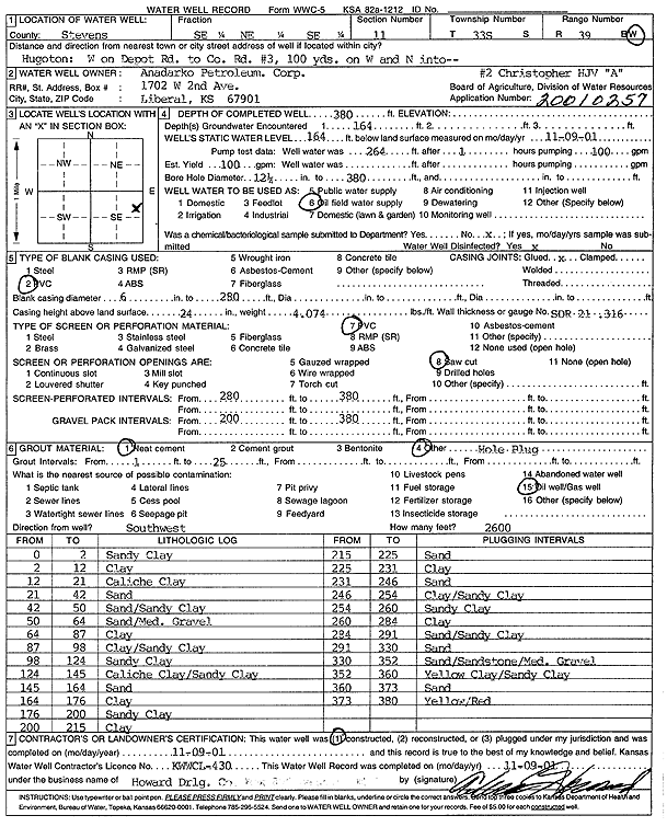
Specific Water Well Detail |
|
|
| Location Info | |||
| Owner: Anadarko Petroleum Corp. | Status: Constructed | ||
| Location: T33S, R39W, Sec. 11, SE NE SE | County: Stevens | ||
| Directions: Hugoton: W on Depot Rd to Colorado Rd #3, 100 yards W, N into site | |||
| Latitude: 37.1891058 | Longitude: -101.5201827 | Datum NAD 27 | |
| Latitude: 37.1891306 | Longitude: -101.5206193 | Datum NAD 83 | |
| Longitude and latitude calculated by Survey from township-range-section-quarter calls. Only good to within the quarter call accuracy. | |||
| View well on interactive map | |||
| General Info | ||
| Well Depth: 380 ft. | Elevation: ft. | |
| Static Water Level: 164 ft. | Est. Yield: 100 gpm. | |
| Comp. Date: 09-Nov-2001 | Well Use: Oil Field Water Supply | |
| DWR Applic. #: 20010257 | Other ID: Christopher HJV A-2 | |
| Links | |
| No Wizard information available. | |
| View info from WIMAS Water Right Data base... | |
| Driller Info | ||
| Driller: Howard Drilling Company AG, LLC | License #: 430 | |
| Scanned Form | View scan |
|
Chemical Sample Submitted?:
Water Well disinfected?: | ||
| Casing Info | ||
| Casing Type:
Casing Joints: |
Diam: in. to ft | |
| Casing height above land surface: in
Casing Weight: lbs/ft Wall thickness or gauge no.: | ||
| Screen and Perforation Info | ||
| Screen Type: | Screen Openings: | |
| Screen-perforated intervals | From: ft to ft | |
| Gravel pack intervals | From: ft to ft | |
| Grout Info | ||
| Grout used: | From: to ft | |
| Source of Possible Contamination | ||
| Source: | ||
| Direction from well: | Distance: ft | |
| Lithologic Log
(Log data entered by KGS.) | ||
| From: 0 ft. to 2 ft. | sandy clay | |
| From: 2 ft. to 12 ft. | clay | |
| From: 12 ft. to 21 ft. | caliche clay | |
| From: 21 ft. to 42 ft. | sand | |
| From: 42 ft. to 50 ft. | sand/sandy clay | |
| From: 50 ft. to 64 ft. | sand/med gravel | |
| From: 64 ft. to 87 ft. | clay | |
| From: 87 ft. to 98 ft. | clay/sandy clay | |
| From: 98 ft. to 124 ft. | sandy clay | |
| From: 124 ft. to 145 ft. | caliche clay/sandy clay | |
| From: 145 ft. to 164 ft. | sand | |
| From: 164 ft. to 176 ft. | clay | |
| From: 176 ft. to 200 ft. | sandy clay | |
| From: 200 ft. to 215 ft. | clay | |
| From: 215 ft. to 225 ft. | sand | |
| From: 225 ft. to 231 ft. | clay | |
| From: 231 ft. to 246 ft. | sand | |
| From: 246 ft. to 254 ft. | clay/sandy clay | |
| From: 254 ft. to 260 ft. | sandy clay | |
| From: 260 ft. to 284 ft. | clay | |
| From: 284 ft. to 291 ft. | sand/sandy clay | |
| From: 291 ft. to 330 ft. | sand | |
| From: 330 ft. to 352 ft. | sand/sandstone/medium gravel | |
| From: 352 ft. to 360 ft. | yellow clay/sandy clay | |
| From: 360 ft. to 373 ft. | sand | |
| From: 373 ft. to 380 ft. | yellow/red | |