|
|
|
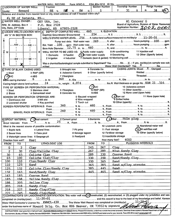
Specific Water Well Detail |
|
|
| Location Info | |||
| Owner: Oxy USA, Inc. | Status: Constructed | ||
| Location: T31S, R34W, Sec. 1, SE SE SW | County: Seward | ||
| Directions: from Satanta: 4.5 mi SE | |||
| Latitude: 37.3740583 | Longitude: -100.9692946 | Datum NAD 27 | |
| Latitude: 37.3740826 | Longitude: -100.969738 | Datum NAD 83 | |
| Longitude and latitude calculated by Survey from township-range-section-quarter calls. Only good to within the quarter call accuracy. | |||
| View well on interactive map | |||
| General Info | ||
| Well Depth: 460 ft. | Elevation: ft. | |
| Static Water Level: 254 ft. | Est. Yield: 100 gpm. | |
| Comp. Date: 20-Nov-2001 | Well Use: Oil Field Water Supply | |
| DWR Applic. #: 20020001 | Other ID: Conover G 1 | |
| Links | |
| No Wizard information available. | |
| View info from WIMAS Water Right Data base... | |
| Driller Info | ||
| Driller: Howard Drilling Company AG, LLC | License #: 430 | |
| Scanned Form | View scan |
|
Chemical Sample Submitted?:
Water Well disinfected?: | ||
| Casing Info | ||
| Casing Type:
Casing Joints: |
Diam: in. to ft | |
| Casing height above land surface: in
Casing Weight: lbs/ft Wall thickness or gauge no.: | ||
| Screen and Perforation Info | ||
| Screen Type: | Screen Openings: | |
| Screen-perforated intervals | From: ft to ft | |
| Gravel pack intervals | From: ft to ft | |
| Grout Info | ||
| Grout used: | From: to ft | |
| Source of Possible Contamination | ||
| Source: | ||
| Direction from well: | Distance: ft | |
| Lithologic Log
(Log data entered by KGS.) | ||
| From: 0 ft. to 2 ft. | clay | |
| From: 2 ft. to 30 ft. | clay/caliche clay | |
| From: 30 ft. to 65 ft. | caliche clay | |
| From: 65 ft. to 100 ft. | caliche clay/clay | |
| From: 100 ft. to 110 ft. | clay/sandy clay | |
| From: 110 ft. to 125 ft. | sand | |
| From: 125 ft. to 132 ft. | caliche clay/sandy clay | |
| From: 132 ft. to 163 ft. | sand/sandy clay | |
| From: 163 ft. to 185 ft. | coarse sand | |
| From: 185 ft. to 198 ft. | yellow sandy clay | |
| From: 198 ft. to 205 ft. | yellow clay | |
| From: 205 ft. to 218 ft. | sandy clay | |
| From: 218 ft. to 227 ft. | sandy clay/clay | |
| From: 227 ft. to 245 ft. | sandy clay/sand | |
| From: 245 ft. to 267 ft. | clay | |
| From: 267 ft. to 289 ft. | blue sandy clay | |
| From: 289 ft. to 330 ft. | coarse sand | |
| From: 330 ft. to 350 ft. | sand/sandy clay | |
| From: 350 ft. to 365 ft. | sand | |
| From: 365 ft. to 385 ft. | sand with clay streaks | |
| From: 385 ft. to 445 ft. | sand | |
| From: 445 ft. to 465 ft. | sand with clay streaks | |