|
|
|
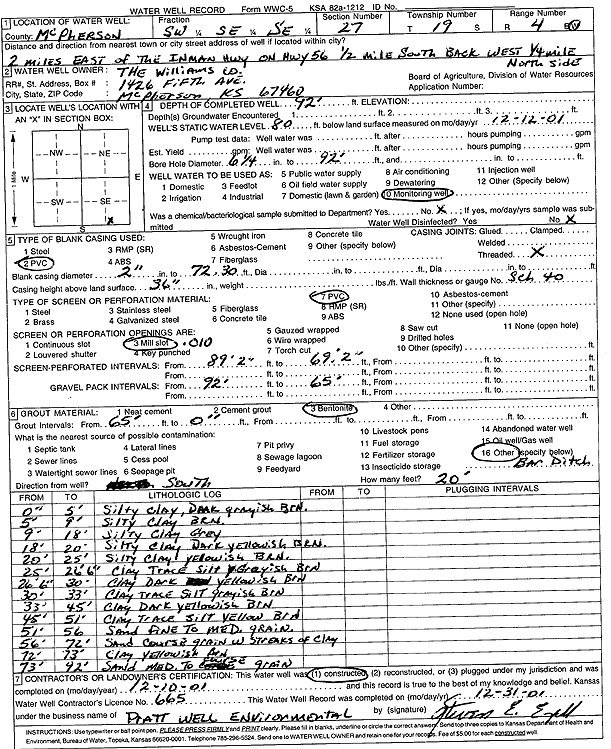
Specific Water Well Detail |
|
|
| Location Info | |||
| Owner: The Williams Co. | Status: Constructed | ||
| Location: T19S, R4W, Sec. 27, SW SE SE | County: McPherson | ||
| Directions: from Inman Hwy: 2 mi E on Hwy 56, .5 mi S, .25 mi W, N side | |||
| Latitude: 38.3631371 | Longitude: -97.7437013 | Datum NAD 27 | |
| Latitude: 38.3631456 | Longitude: -97.7440239 | Datum NAD 83 | |
| Longitude and latitude calculated by Survey from township-range-section-quarter calls. Only good to within the quarter call accuracy. | |||
| View well on interactive map | |||
| General Info | ||
| Well Depth: 92 ft. | Elevation: ft. | |
| Static Water Level: 80 ft. | Est. Yield: gpm. | |
| Comp. Date: 10-Dec-2001 | Well Use: Monitoring well/observation/piezometer | |
| DWR Applic. #: | Other ID: | |
| Driller Info | ||
| Driller: Pratt Well Service, Inc. | License #: 665 | |
| Scanned Form | View scan |
|
Chemical Sample Submitted?:
Water Well disinfected?: | ||
| Casing Info | ||
| Casing Type:
Casing Joints: |
Diam: in. to ft | |
| Casing height above land surface: in
Casing Weight: lbs/ft Wall thickness or gauge no.: | ||
| Screen and Perforation Info | ||
| Screen Type: | Screen Openings: | |
| Screen-perforated intervals | From: ft to ft | |
| Gravel pack intervals | From: ft to ft | |
| Grout Info | ||
| Grout used: | From: to ft | |
| Source of Possible Contamination | ||
| Source: | ||
| Direction from well: | Distance: ft | |
| Lithologic Log
(Log data entered by KGS.) | ||
| From: 0 ft. to 5 ft. | silty clay, dark grayish brown | |
| From: 5 ft. to 9 ft. | silty clay, brown | |
| From: 9 ft. to 18 ft. | silty clay, gray | |
| From: 18 ft. to 20 ft. | silty clay, dark yellowish brown | |
| From: 20 ft. to 25 ft. | silty clay, yellowish brown | |
| From: 25 ft. to 26.5 ft. | clay with trace silt, grayish brown | |
| From: 26.5 ft. to 30 ft. | clay, dark yellowish brown | |
| From: 30 ft. to 33 ft. | clay, trace silt, grayish brown | |
| From: 33 ft. to 45 ft. | clay, dark yellowish brown | |
| From: 45 ft. to 51 ft. | clay with trace silt, yellow brown | |
| From: 51 ft. to 56 ft. | fine to medium sand | |
| From: 56 ft. to 72 ft. | coarse sand with streaks of clay | |
| From: 72 ft. to 73 ft. | clay, yellowish brown | |
| From: 73 ft. to 92 ft. | medium to coarse sand | |