|
|
|
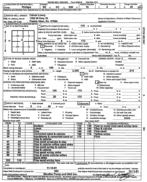
Specific Water Well Detail |
|
|
| Location Info | |||
| Owner: Lowry, Calvin | Status: Constructed | ||
| Location: T3S, R20W, Sec. 16, SE SE NW | County: Phillips | ||
| Directions: | |||
| Latitude: 39.7930003 | Longitude: -99.5814362 | Datum NAD 27 | |
| Latitude: 39.7930083 | Longitude: -99.5818218 | Datum NAD 83 | |
| Longitude and latitude calculated by Survey from township-range-section-quarter calls. Only good to within the quarter call accuracy. | |||
| View well on interactive map | |||
| General Info | ||
| Well Depth: 170 ft. | Elevation: ft. | |
| Static Water Level: ft. | Est. Yield: gpm. | |
| Comp. Date: 14-Nov-2001 | Well Use: Domestic | |
| DWR Applic. #: | Other ID: | |
| Driller Info | ||
| Driller: Jay C. Woofter Pump & Well, Inc. | License #: 554 | |
| Scanned Form | View scan |
|
Chemical Sample Submitted?:
Water Well disinfected?: | ||
| Casing Info | ||
| Casing Type:
Casing Joints: |
Diam: in. to ft | |
| Casing height above land surface: in
Casing Weight: lbs/ft Wall thickness or gauge no.: | ||
| Screen and Perforation Info | ||
| Screen Type: | Screen Openings: | |
| Screen-perforated intervals | From: ft to ft | |
| Gravel pack intervals | From: ft to ft | |
| Grout Info | ||
| Grout used: | From: to ft | |
| Source of Possible Contamination | ||
| Source: | ||
| Direction from well: | Distance: ft | |
| Lithologic Log
(Log data entered by KGS.) | ||
| From: 0 ft. to 2 ft. | surface | |
| From: 2 ft. to 10 ft. | loess | |
| From: 10 ft. to 18 ft. | clay | |
| From: 18 ft. to 34 ft. | cemented sand and caliche | |
| From: 34 ft. to 41 ft. | sandstone and cemented sand with clay and caliche | |
| From: 41 ft. to 49 ft. | fine sand with caliche and clay | |
| From: 49 ft. to 62 ft. | clay and caliche with fine sand streaks | |
| From: 62 ft. to 71 ft. | fine sand with clay and caliche | |
| From: 71 ft. to 80 ft. | clay and caliche | |
| From: 80 ft. to 88 ft. | fine sand with clay streaks | |
| From: 88 ft. to 103 ft. | clay and some caliche with fine sand streaks | |
| From: 103 ft. to 110 ft. | fine sand with clay lens | |
| From: 110 ft. to 128 ft. | fine to some medium sand with clay lens | |
| From: 128 ft. to 144 ft. | clay and caliche | |
| From: 144 ft. to 168 ft. | fine sand | |
| From: 168 ft. to 170 ft. | yellow ochre | |
| From: 170 ft. to ft. | flint | |