|
|
|
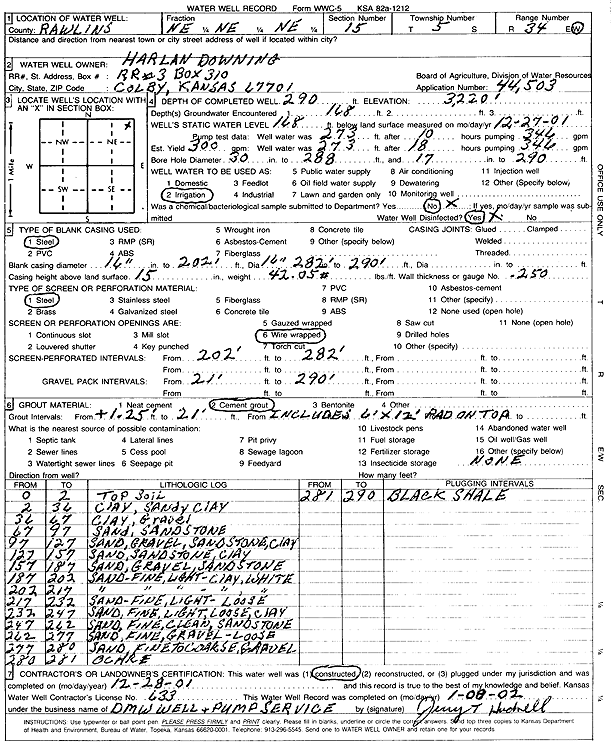
Specific Water Well Detail |
|
|
| Location Info | |||
| Owner: Downing, Harlan | Status: Constructed | ||
| Location: T5S, R34W, Sec. 15, NE NE NE | County: Rawlins | ||
| Directions: | |||
| Latitude: 39.6250712 | Longitude: -101.1141259 | Datum NAD 27 | |
| Latitude: 39.6250722 | Longitude: -101.114561 | Datum NAD 83 | |
| Longitude and latitude calculated by Survey from township-range-section-quarter calls. Only good to within the quarter call accuracy. | |||
| View well on interactive map | |||
| General Info | ||
| Well Depth: 290 ft. | Elevation: 3220 ft. | |
| Static Water Level: 168 ft. | Est. Yield: 300 gpm. | |
| Comp. Date: 28-Dec-2001 | Well Use: Irrigation | |
| DWR Applic. #: 44503 | Other ID: | |
| Links | |
| View info from Wizard Water Level Data base... | |
| View info from WIMAS Water Right Data base... | |
| Driller Info | ||
| Driller: DMW Well & Pump Service | License #: 633 | |
| Scanned Form | View scan |
|
Chemical Sample Submitted?: No
Water Well disinfected?: Yes | ||
| Ground water encountered: 168 ft. | ||
| Pump test data: Well water was 273 ft after 10 hours pumping 346 gpm Well water was 273 ft after 18 hours pumping 346 gpm | ||
| Bore hole diameter: 30 inches to 288 ft and 17 inches to 290 ft | ||
| Casing Info | ||
| Casing Type: Steel
Casing Joints: |
Diam: 16 in. to 202 ft
Diam: 16 in. to 282 ft Diam: 16 in. to 290 ft | |
| Casing height above land surface: 15 in
Casing Weight: 42.05 lbs/ft Wall thickness or gauge no.: .250 | ||
| Screen and Perforation Info | ||
| Screen Type: Steel | Screen Openings: Wire wrapped | |
| Screen-perforated intervals | From: 202 ft to 282 ft | |
| Gravel pack intervals | From: 21 ft to 290 ft | |
| Grout Info | ||
| Grout used: Cement grout, 6'x12' Pad on Top | From: 1.25 to 21 ft | |
| Source of Possible Contamination | ||
| Source: None | ||
| Direction from well: | Distance: ft | |
| Lithologic Log
(Log data entered by KGS.) | ||
| From: 0 ft. to 2 ft. | top soil | |
| From: 2 ft. to 36 ft. | clay, sandy clay | |
| From: 36 ft. to 67 ft. | clay, gravel | |
| From: 67 ft. to 97 ft. | sand, sandstone | |
| From: 97 ft. to 127 ft. | sand, gravel, sandstone, clay | |
| From: 127 ft. to 157 ft. | sand, sandstone, clay | |
| From: 157 ft. to 187 ft. | sand, gravel, sandstone | |
| From: 187 ft. to 202 ft. | sand, fine, light clay, white | |
| From: 202 ft. to 217 ft. | sand, fine, light clay, white | |
| From: 217 ft. to 232 ft. | sand, fine, light, loose | |
| From: 232 ft. to 247 ft. | sand, fine, light, loose, clay | |
| From: 247 ft. to 262 ft. | sand, fine, clean, sandstone | |
| From: 262 ft. to 277 ft. | sand, fine, gravel, loose | |
| From: 277 ft. to 280 ft. | sand, fine to coarse, gravel | |
| From: 280 ft. to 281 ft. | ochre | |
| From: 281 ft. to 290 ft. | black shale | |