|
|
|
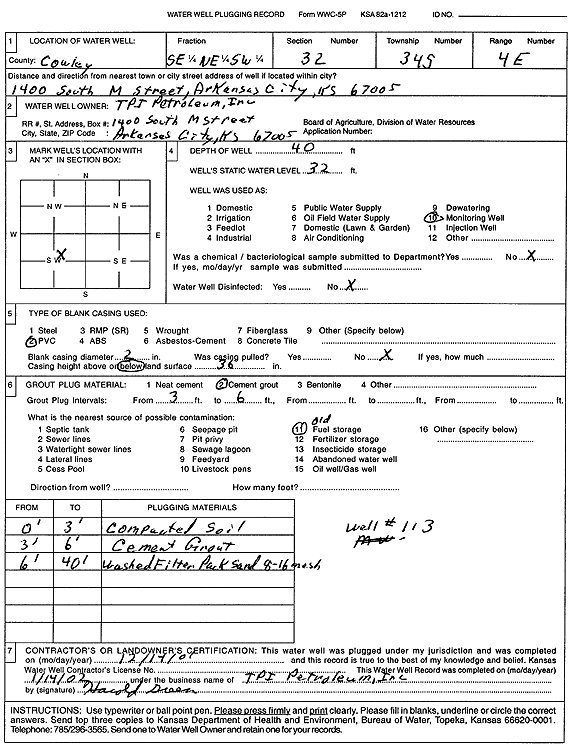
Specific Water Well Detail |
|
|
| Location Info | |||
| Owner: TPI Petroleum, Inc. | Status: Plugged | ||
| Location: T34S, R4E, Sec. 32, SE NE SW | County: Cowley | ||
| Directions: 1400 S M St, Arkansas City | |||
| Latitude: 37.046263 | Longitude: -97.0138096 | Datum NAD 27 | |
| Latitude: 37.0462927 | Longitude: -97.0141248 | Datum NAD 83 | |
| Longitude and latitude calculated by Survey from township-range-section-quarter calls. Only good to within the quarter call accuracy. | |||
| View well on interactive map | |||
| General Info | ||
| Well Depth: 40 ft. | Elevation: ft. | |
| Static Water Level: 32 ft. | Est. Yield: gpm. | |
| Comp. Date: 14-Dec-2001 | Well Use: Monitoring well/observation/piezometer | |
| DWR Applic. #: | Other ID: Well 113 | |
| Driller Info | ||
| Driller: TPI Petroleum, Inc. | License #: | |
| Scanned Form | View scan |
| Casing Info | ||
|
Casing Type:
Diam: in. Casing height above land surface: in | ||
| Grout Info | ||
| Grout used: | From: to ft | |
| Source of Possible Contamination | ||
| Source: | ||
| Direction from well: | Distance: ft | |