|
|
|
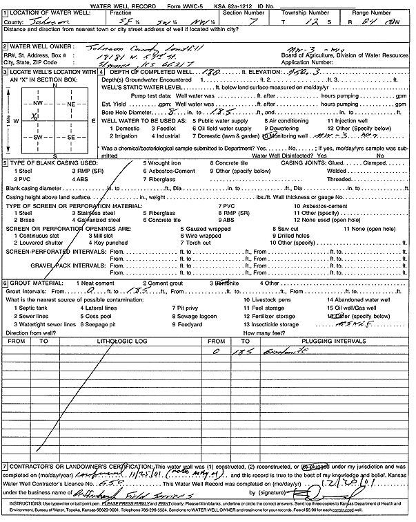
Specific Water Well Detail |
|
|
| Location Info | |||
| Owner: Johnson County Landfill | Status: Plugged | ||
| Location: T12S, R24E, Sec. 7, SE SW NW | County: Johnson | ||
| Directions: | |||
| Latitude: 39.0228713 | Longitude: -94.7939657 | Datum NAD 27 | |
| Latitude: 39.0228764 | Longitude: -94.7942055 | Datum NAD 83 | |
| Longitude and latitude calculated by Survey from township-range-section-quarter calls. Only good to within the quarter call accuracy. | |||
| View well on interactive map | |||
| General Info | ||
| Well Depth: 180 ft. | Elevation: 950.3 ft. | |
| Static Water Level: ft. | Est. Yield: gpm. | |
| Comp. Date: 25-Nov-2001 | Well Use: Monitoring well/observation/piezometer | |
| DWR Applic. #: | Other ID: MW 3 | |
| Driller Info | ||
| Driller: Ron Wood, Deffenbaugh Field Services | License #: 650 | |
| Scanned Form | View scan |
| Casing Info | ||
|
Casing Type:
Diam: in. Casing height above land surface: in | ||
| Grout Info | ||
| Grout used: | From: to ft | |
| Source of Possible Contamination | ||
| Source: | ||
| Direction from well: | Distance: ft | |