|
|
|
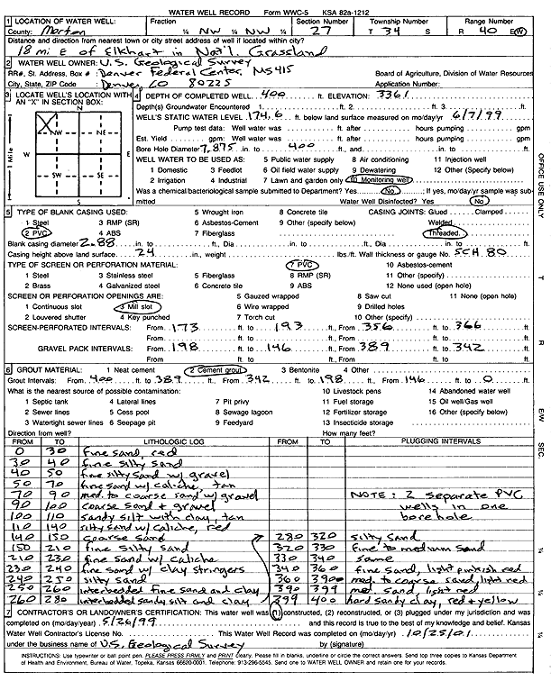
Specific Water Well Detail |
|
|
| Location Info | |||
| Owner: U.S. Geological Survey | Status: Constructed | ||
| Location: T34S, R40W, Sec. 27, NW NW | County: Morton | ||
| Directions: from Elkhart: 18 mi E in Cimarron National Grassland | |||
| Latitude: 37.0672145 | Longitude: -101.6615208 | Datum NAD 27 | |
| Latitude: 37.06724 | Longitude: -101.66196 | Datum NAD 83 | |
| Longitude and latitude calculated by Survey from township-range-section-quarter calls. Only good to within the quarter call accuracy. | |||
| View well on interactive map | |||
| General Info | ||
| Well Depth: 400 ft. | Elevation: 3361 ft. | |
| Static Water Level: 174.6 ft. | Est. Yield: gpm. | |
| Comp. Date: 26-May-1999 | Well Use: Monitoring well/observation/piezometer | |
| DWR Applic. #: | Other ID: | |
| Links | |
| View info from Wizard Water Level Data base... | |
| No WIMAS information available. | |
| Driller Info | ||
| Driller: U.S. Geological Survey | License #: | |
| Scanned Form | View scan |
|
Chemical Sample Submitted?: No
Water Well disinfected?: No | ||
| Bore hole diameter: 7.88 inches to 400 ft | ||
| Casing Info | ||
| Casing Type: PVC
Casing Joints: Threaded |
Diam: 2.88 in. to ft | |
| Casing height above land surface: 24 in
Casing Weight: lbs/ft Wall thickness or gauge no.: SCH 80 | ||
| Screen and Perforation Info | ||
| Screen Type: PVC | Screen Openings: Mill slot | |
| Screen-perforated intervals | From: 173 ft to 193 ft
From: 356 ft to 366 ft | |
| Gravel pack intervals | From: 198 ft to 146 ft
From: 389 ft to 342 ft | |
| Grout Info | ||
| Grout used: Cement grout | From: 400 to 389 ft
From: 342 to 198 ft From: 146 to 0 ft | |
| Source of Possible Contamination | ||
| Source: | ||
| Direction from well: | Distance: ft | |
| Lithologic Log
(Log data entered by KGS.) | ||
| From: 0 ft. to 30 ft. | fine sand, red | |
| From: 30 ft. to 40 ft. | fine silty sand | |
| From: 40 ft. to 50 ft. | fine silty sand with gravel | |
| From: 50 ft. to 70 ft. | fine sand with caliche, tan | |
| From: 70 ft. to 90 ft. | med to coarse sand with gravel | |
| From: 90 ft. to 100 ft. | coarse sand and gravel | |
| From: 100 ft. to 110 ft. | sandy silt with clay, tan | |
| From: 110 ft. to 140 ft. | silty sand with caliche, red | |
| From: 140 ft. to 150 ft. | coarse sand | |
| From: 150 ft. to 210 ft. | fine silty sand | |
| From: 210 ft. to 230 ft. | fine sand with caliche | |
| From: 230 ft. to 240 ft. | fine sand with clay stringers | |
| From: 240 ft. to 250 ft. | silty sand | |
| From: 250 ft. to 260 ft. | interbedded fine sand and clay | |
| From: 260 ft. to 280 ft. | interbedded sandy silt and clay | |
| From: 280 ft. to 320 ft. | silty sand | |
| From: 320 ft. to 330 ft. | fine to medium sand | |
| From: 330 ft. to 340 ft. | same | |
| From: 340 ft. to 360 ft. | fine sand, light pinkish red | |
| From: 360 ft. to 390 ft. | medium to coarse sand, light red | |
| From: 390 ft. to 399 ft. | med sand, light red | |
| From: 399 ft. to 400 ft. | hard sandy clay, red and yellow | |