|
|
|
Specific Water Well Detail |
|
|
| Location Info | |||
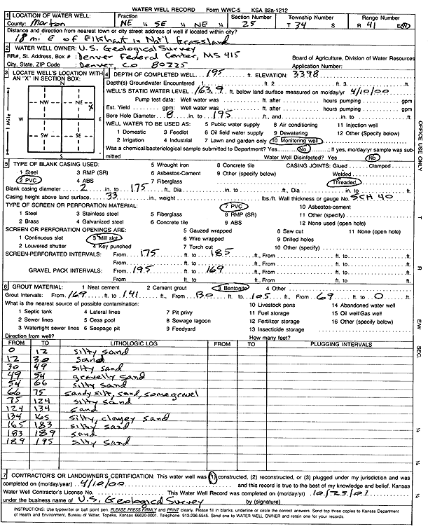
| Owner: U.S. Geological Survey | Status: Constructed | ||
| Location: T34S, R41W, Sec. 25, NE SE NE | County: Morton | ||
| Directions: from Elkhart: 18 mi E in Cimarron National Grassland | |||
| Latitude: 37.064403 | Longitude: -101.7190075 | Datum NAD 27 | |
| Latitude: 37.064428 | Longitude: -101.7194475 | Datum NAD 83 | |
| Longitude and latitude calculated by Survey from township-range-section-quarter calls. Only good to within the quarter call accuracy. | |||
| View well on interactive map | |||
| General Info | ||
| Well Depth: 195 ft. | Elevation: 3398 ft. | |
| Static Water Level: 163.9 ft. | Est. Yield: gpm. | |
| Comp. Date: 10-Apr-2000 | Well Use: Monitoring well/observation/piezometer | |
| DWR Applic. #: | Other ID: | |
| Driller Info | ||
| Driller: U.S. Geological Survey | License #: | |
| Scanned Form | View scan |
|
Chemical Sample Submitted?:
Water Well disinfected?: | ||
| Casing Info | ||
| Casing Type:
Casing Joints: |
Diam: in. to ft | |
| Casing height above land surface: in
Casing Weight: lbs/ft Wall thickness or gauge no.: | ||
| Screen and Perforation Info | ||
| Screen Type: | Screen Openings: | |
| Screen-perforated intervals | From: ft to ft | |
| Gravel pack intervals | From: ft to ft | |
| Grout Info | ||
| Grout used: | From: to ft | |
| Source of Possible Contamination | ||
| Source: | ||
| Direction from well: | Distance: ft | |
| Lithologic Log
(Log data entered by KGS.) | ||
| From: 0 ft. to 12 ft. | silty sand | |
| From: 12 ft. to 30 ft. | sand | |
| From: 30 ft. to 49 ft. | silty sand | |
| From: 49 ft. to 54 ft. | gravelly sand | |
| From: 54 ft. to 66 ft. | silty sand | |
| From: 66 ft. to 75 ft. | sandy silt, sand, some gravel | |
| From: 75 ft. to 124 ft. | silty sand | |
| From: 124 ft. to 134 ft. | sand | |
| From: 134 ft. to 165 ft. | silty, clayey sand | |
| From: 165 ft. to 183 ft. | silty sand | |
| From: 183 ft. to 189 ft. | sand | |
| From: 189 ft. to 195 ft. | silty sand | |