|
|
|
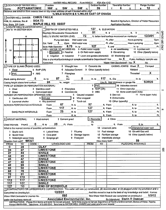
Specific Water Well Detail |
|
|
| Location Info | |||
| Owner: Faulk, Chris | Status: Constructed | ||
| Location: T6S, R12E, Sec. 35, NW SW SW | County: Pottawatomie | ||
| Directions: from Onaga: .5 mi S, 6.25 mi E | |||
| Latitude: 39.4807872 | Longitude: -96.0526203 | Datum NAD 27 | |
| Latitude: 39.4807824 | Longitude: -96.0528933 | Datum NAD 83 | |
| Longitude and latitude calculated by Survey from township-range-section-quarter calls. Only good to within the quarter call accuracy. | |||
| View well on interactive map | |||
| General Info | ||
| Well Depth: 127 ft. | Elevation: ft. | |
| Static Water Level: 72 ft. | Est. Yield: 1 gpm. | |
| Comp. Date: 03-Dec-2001 | Well Use: Domestic | |
| DWR Applic. #: | Other ID: WW 229 | |
| Driller Info | ||
| Driller: Associated Environmental, Inc. | License #: 585 | |
| Scanned Form | View scan |
|
Chemical Sample Submitted?:
Water Well disinfected?: | ||
| Casing Info | ||
| Casing Type:
Casing Joints: |
Diam: in. to ft | |
| Casing height above land surface: in
Casing Weight: lbs/ft Wall thickness or gauge no.: | ||
| Screen and Perforation Info | ||
| Screen Type: | Screen Openings: | |
| Screen-perforated intervals | From: ft to ft | |
| Gravel pack intervals | From: ft to ft | |
| Grout Info | ||
| Grout used: | From: to ft | |
| Source of Possible Contamination | ||
| Source: | ||
| Direction from well: | Distance: ft | |
| Lithologic Log
(Log data entered by KGS.) | ||
| From: 0 ft. to 24 ft. | clay | |
| From: 24 ft. to 27 ft. | limestone | |
| From: 27 ft. to 44 ft. | shale | |
| From: 44 ft. to 45 ft. | limestone | |
| From: 45 ft. to 47 ft. | shale | |
| From: 47 ft. to 48 ft. | limestone | |
| From: 48 ft. to 66 ft. | shale | |
| From: 66 ft. to 68 ft. | limestone | |
| From: 68 ft. to 78 ft. | shale | |
| From: 78 ft. to 81 ft. | limestone | |
| From: 81 ft. to 113 ft. | shale | |
| From: 113 ft. to 117 ft. | limestone | |
| From: 117 ft. to 127 ft. | shale | |