|
|
|
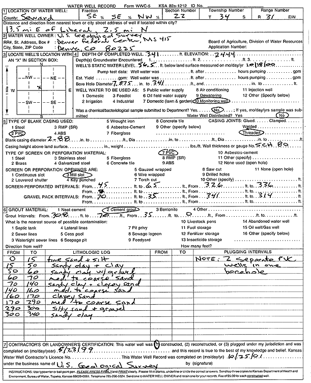
Specific Water Well Detail |
|
|
| Location Info | |||
| Owner: U. S. Geological Survey | Status: Constructed | ||
| Location: T34S, R31W, Sec. 22, SE SE NW | County: Seward | ||
| Directions: from Liberal: 13.5 mi E, 2.5 mi N | |||
| Latitude: 37.0764317 | Longitude: -100.6801265 | Datum NAD 27 | |
| Latitude: 37.0764558 | Longitude: -100.6805611 | Datum NAD 83 | |
| Longitude and latitude calculated by Survey from township-range-section-quarter calls. Only good to within the quarter call accuracy. | |||
| View well on interactive map | |||
| General Info | ||
| Well Depth: 341 ft. | Elevation: 2510 ft. | |
| Static Water Level: 56.5 ft. | Est. Yield: gpm. | |
| Comp. Date: 23-May-1999 | Well Use: Monitoring well/observation/piezometer | |
| DWR Applic. #: | Other ID: | |
| Links | |
| View info from Wizard Water Level Data base... | |
| No WIMAS information available. | |
| Driller Info | ||
| Driller: U.S. Geological Survey | License #: | |
| Scanned Form | View scan |
|
Chemical Sample Submitted?: No
Water Well disinfected?: No | ||
| Bore hole diameter: 8 inches to 341 ft | ||
| Casing Info | ||
| Casing Type: PVC
Casing Joints: Threaded |
Diam: 2.88 in. to ft | |
| Casing height above land surface: in
Casing Weight: lbs/ft Wall thickness or gauge no.: Sch. 80 | ||
| Screen and Perforation Info | ||
| Screen Type: PVC | Screen Openings: Mill slot | |
| Screen-perforated intervals | From: 45 ft to 65 ft
From: 326 ft to 336 ft | |
| Gravel pack intervals | From: 70 ft to 35 ft
From: 341 ft to 314 ft | |
| Grout Info | ||
| Grout used: Cement grout | From: 308 to 70 ft | |
| Source of Possible Contamination | ||
| Source: | ||
| Direction from well: | Distance: ft | |
| Lithologic Log
(Log data entered by KGS.) | ||
| From: 0 ft. to 15 ft. | fine sand and silt | |
| From: 15 ft. to 50 ft. | sandy clay and clay | |
| From: 50 ft. to 60 ft. | sandy clay with gravel | |
| From: 60 ft. to 70 ft. | med to coarse sand | |
| From: 70 ft. to 140 ft. | sandy clay and clayey sand | |
| From: 140 ft. to 160 ft. | med to coarse sand | |
| From: 160 ft. to 170 ft. | clayey sand | |
| From: 170 ft. to 290 ft. | med to coarse sand | |
| From: 290 ft. to 300 ft. | silty sand and gravel | |
| From: 300 ft. to 340 ft. | sandy clay | |