|
|
|
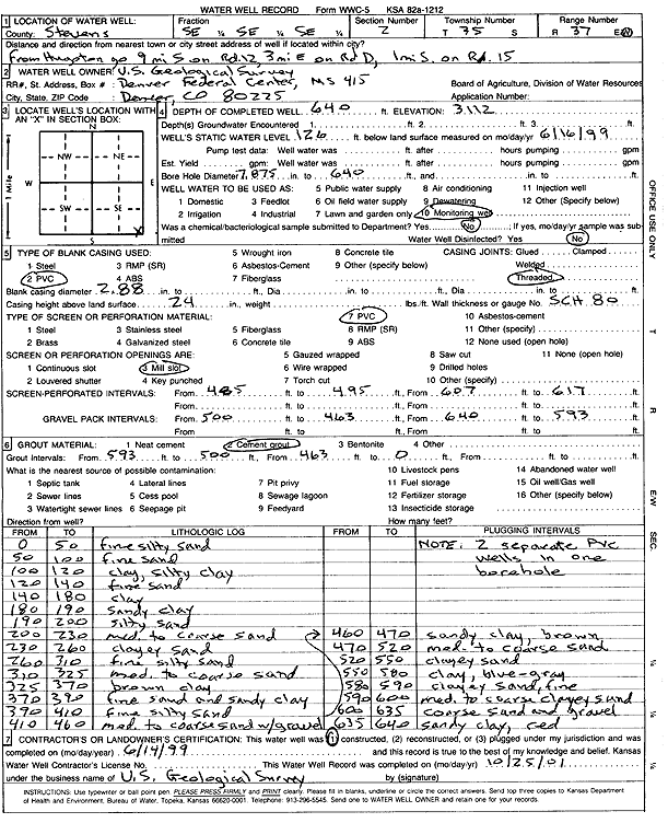
Specific Water Well Detail |
|
|
| Location Info | |||
| Owner: U.S. Geological Survey | Status: Constructed | ||
| Location: T35S, R37W, Sec. 2, SE SE SE | County: Stevens | ||
| Directions: from Hugoton: 9 mi S on Rd 12, 3 mi E on Rd D, 1 mi S on Rd 15 | |||
| Latitude: 37.0258812 | Longitude: -101.3030048 | Datum NAD 27 | |
| Latitude: 37.0259074 | Longitude: -101.303444 | Datum NAD 83 | |
| Longitude and latitude calculated by Survey from township-range-section-quarter calls. Only good to within the quarter call accuracy. | |||
| View well on interactive map | |||
| General Info | ||
| Well Depth: 640 ft. | Elevation: 3112 ft. | |
| Static Water Level: 126 ft. | Est. Yield: gpm. | |
| Comp. Date: 14-Jun-1999 | Well Use: Monitoring well/observation/piezometer | |
| DWR Applic. #: | Other ID: | |
| Links | |
| View info from Wizard Water Level Data base... | |
| No WIMAS information available. | |
| Driller Info | ||
| Driller: USGS | License #: | |
| Scanned Form | View scan |
|
Chemical Sample Submitted?: No
Water Well disinfected?: No | ||
| Bore hole diameter: 7.88 inches to 640 ft | ||
| Casing Info | ||
| Casing Type: PVC
Casing Joints: Threaded |
Diam: 2.88 in. to ft | |
| Casing height above land surface: 24 in
Casing Weight: lbs/ft Wall thickness or gauge no.: SCH 80 | ||
| Screen and Perforation Info | ||
| Screen Type: PVC | Screen Openings: Mill slot | |
| Screen-perforated intervals | From: 485 ft to 495 ft
From: 607 ft to 617 ft | |
| Gravel pack intervals | From: 500 ft to 463 ft
From: 640 ft to 593 ft | |
| Grout Info | ||
| Grout used: Cement grout | From: 593 to 500 ft
From: 463 to 0 ft | |
| Source of Possible Contamination | ||
| Source: | ||
| Direction from well: | Distance: ft | |
| Lithologic Log
(Log data entered by KGS.) | ||
| From: 0 ft. to 50 ft. | fine silty sand | |
| From: 50 ft. to 100 ft. | fine sand | |
| From: 100 ft. to 120 ft. | clay, silty clay | |
| From: 120 ft. to 140 ft. | fine sand | |
| From: 140 ft. to 180 ft. | clay | |
| From: 180 ft. to 190 ft. | sandy clay | |
| From: 190 ft. to 200 ft. | silty sand | |
| From: 200 ft. to 230 ft. | med to coarse sand | |
| From: 230 ft. to 260 ft. | clayey sand | |
| From: 260 ft. to 310 ft. | fine silty sand | |
| From: 310 ft. to 325 ft. | med to coarse sand | |
| From: 325 ft. to 370 ft. | brown clay | |
| From: 370 ft. to 390 ft. | fine sand and sandy clay | |
| From: 390 ft. to 410 ft. | fine silty sand | |
| From: 410 ft. to 460 ft. | med to coarse sand with gravel | |
| From: 460 ft. to 470 ft. | sandy clay, brown | |
| From: 470 ft. to 520 ft. | med to coarse sand | |
| From: 520 ft. to 550 ft. | clayey sand | |
| From: 550 ft. to 580 ft. | clay, blue-gray | |
| From: 580 ft. to 590 ft. | clayey sand, fine | |
| From: 590 ft. to 600 ft. | med to coarse clayey sand | |
| From: 600 ft. to 635 ft. | coarse sand and gravel | |
| From: 635 ft. to 640 ft. | sandy clay, red | |