|
|
|
Specific Water Well Detail |
|
|
| Location Info | |||
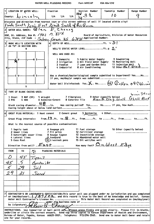
| Owner: Cheney, Glen E. | Status: Plugged | ||
| Location: T10S, R9W, Sec. 32, NW | County: Lincoln | ||
| Directions: from Ash Grove: 1 mi S, .25 mi E, .25 mi S | |||
| Latitude: 39.1431228 | Longitude: -98.3541918 | Datum NAD 27 | |
| Latitude: 39.1431313 | Longitude: -98.3545291 | Datum NAD 83 | |
| Longitude and latitude calculated by Survey from township-range-section-quarter calls. Only good to within the quarter call accuracy. | |||
| View well on interactive map | |||
| General Info | ||
| Well Depth: 31 ft. | Elevation: ft. | |
| Static Water Level: 2 ft. | Est. Yield: gpm. | |
| Comp. Date: 27-Jan-2002 | Well Use: (unstated)/abandoned | |
| DWR Applic. #: | Other ID: | |
| Driller Info | ||
| Driller: Glen E. Cheney | License #: | |
| Scanned Form | View scan |
| Casing Info | ||
|
Casing Type:
Diam: in. Casing height above land surface: in | ||
| Grout Info | ||
| Grout used: | From: to ft | |
| Source of Possible Contamination | ||
| Source: | ||
| Direction from well: | Distance: ft | |