|
|
|
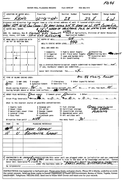
Specific Water Well Detail |
|
|
| Location Info | |||
| Owner: Kansas Gas Service | Status: Plugged | ||
| Location: T22S, R6W, Sec. 28, SW SE NW | County: Reno | ||
| Directions: W 50th St at Cow Creek: E ditch, 24.25 feet E, 14 feet N of telephone pole, N side of Cow Creek | |||
| Latitude: 38.1085057 | Longitude: -97.9902525 | Datum NAD 27 | |
| Latitude: 38.1085168 | Longitude: -97.9905837 | Datum NAD 83 | |
| Longitude and latitude calculated by Survey from township-range-section-quarter calls. Only good to within the quarter call accuracy. | |||
| View well on interactive map | |||
| General Info | ||
| Well Depth: 64 ft. | Elevation: ft. | |
| Static Water Level: ft. | Est. Yield: gpm. | |
| Comp. Date: 16-Jan-2002 | Well Use: Monitoring well/observation/piezometer | |
| DWR Applic. #: | Other ID: PD 34 | |
| Driller Info | ||
| Driller: Pratt Well Service, Inc. | License #: 665 | |
| Scanned Form | View scan |
| Casing Info | ||
|
Casing Type:
Diam: in. Casing height above land surface: in | ||
| Grout Info | ||
| Grout used: | From: to ft | |
| Source of Possible Contamination | ||
| Source: | ||
| Direction from well: | Distance: ft | |