|
|
|
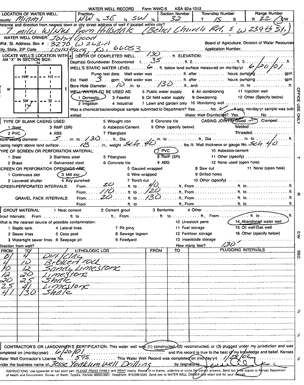
Specific Water Well Detail |
|
|
| Location Info | |||
| Owner: Good, John | Status: Constructed | ||
| Location: T15S, R22E, Sec. 32, NW SE SW | County: Miami | ||
| Directions: Bethel Church Rd and W 239th St - from Hillsdale: 7 mi WNW | |||
| Latitude: 38.6975693 | Longitude: -94.994805 | Datum NAD 27 | |
| Latitude: 38.6975791 | Longitude: -94.9950492 | Datum NAD 83 | |
| Longitude and latitude calculated by Survey from township-range-section-quarter calls. Only good to within the quarter call accuracy. | |||
| View well on interactive map | |||
| General Info | ||
| Well Depth: 130 ft. | Elevation: ft. | |
| Static Water Level: 6 ft. | Est. Yield: 3 gpm. | |
| Comp. Date: 20-Jun-2001 | Well Use: Domestic | |
| DWR Applic. #: | Other ID: | |
| Driller Info | ||
| Driller: Jesse Yoakum Well Drilling | License #: 595 | |
| Scanned Form | View scan |
|
Chemical Sample Submitted?:
Water Well disinfected?: | ||
| Casing Info | ||
| Casing Type:
Casing Joints: |
Diam: in. to ft | |
| Casing height above land surface: in
Casing Weight: lbs/ft Wall thickness or gauge no.: | ||
| Screen and Perforation Info | ||
| Screen Type: | Screen Openings: | |
| Screen-perforated intervals | From: ft to ft | |
| Gravel pack intervals | From: ft to ft | |
| Grout Info | ||
| Grout used: | From: to ft | |
| Source of Possible Contamination | ||
| Source: | ||
| Direction from well: | Distance: ft | |
| Lithologic Log
(Log data entered by KGS.) | ||
| From: 0 ft. to 4 ft. | Dirt/clay | |
| From: 4 ft. to 10 ft. | Broken rock | |
| From: 10 ft. to 12 ft. | Sandy limestone | |
| From: 12 ft. to 20 ft. | Limestone | |
| From: 20 ft. to 25 ft. | Shale | |
| From: 25 ft. to 41 ft. | Limestone | |
| From: 41 ft. to 130 ft. | Shale | |