|
|
|
Specific Water Well Detail |
|
|
| Location Info | |||
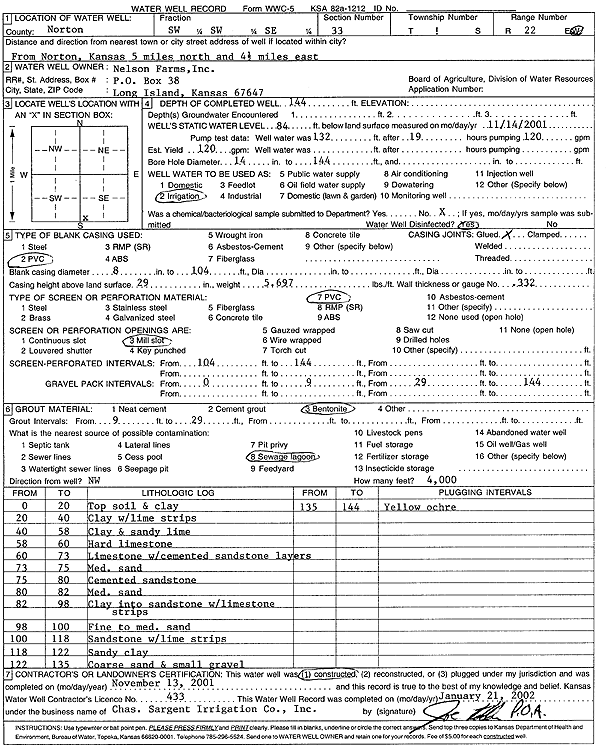
| Owner: Nelson Farms Inc. | Status: Constructed | ||
| Location: T1S, R22W, Sec. 33, SW SW SE | County: Norton | ||
| Directions: from Norton: 5 mi N, 4.5 mi E | |||
| Latitude: 39.9154123 | Longitude: -99.8031168 | Datum NAD 27 | |
| Latitude: 39.9154189 | Longitude: -99.8035127 | Datum NAD 83 | |
| Longitude and latitude calculated by Survey from township-range-section-quarter calls. Only good to within the quarter call accuracy. | |||
| View well on interactive map | |||
| General Info | ||
| Well Depth: 144 ft. | Elevation: ft. | |
| Static Water Level: 84 ft. | Est. Yield: 120 gpm. | |
| Comp. Date: 13-Nov-2001 | Well Use: Irrigation | |
| DWR Applic. #: | Other ID: | |
| Links | |
| View info from Wizard Water Level Data base... | |
| View info from WIMAS Water Right Data base... | |
| Driller Info | ||
| Driller: Chas. Sargent Irrigation Co., Inc. | License #: 433 | |
| Scanned Form | View scan |
|
Chemical Sample Submitted?:
Water Well disinfected?: | ||
| Casing Info | ||
| Casing Type: PVC
Casing Joints: |
Diam: 8 in. to 104 ft | |
| Casing height above land surface: in
Casing Weight: lbs/ft Wall thickness or gauge no.: | ||
| Screen and Perforation Info | ||
| Screen Type: PVC | Screen Openings: | |
| Screen-perforated intervals | From: 104 ft to 144 ft | |
| Gravel pack intervals | From: ft to ft | |
| Grout Info | ||
| Grout used: | From: to ft | |
| Source of Possible Contamination | ||
| Source: | ||
| Direction from well: | Distance: ft | |
| Lithologic Log
(Log data entered by KGS.) | ||
| From: 0 ft. to 20 ft. | topsoil and clay | |
| From: 20 ft. to 40 ft. | clay with lime strips | |
| From: 40 ft. to 58 ft. | clay and sandy lime | |
| From: 58 ft. to 60 ft. | hard limestone | |
| From: 60 ft. to 73 ft. | limestone with cemented sandstone layers | |
| From: 73 ft. to 75 ft. | medium sand | |
| From: 75 ft. to 80 ft. | cemented sandstone | |
| From: 80 ft. to 82 ft. | medium sand | |
| From: 82 ft. to 98 ft. | clay into sandstone with limestone strips | |
| From: 98 ft. to 100 ft. | fine to medium sand | |
| From: 100 ft. to 118 ft. | sandstone with lime strips | |
| From: 118 ft. to 122 ft. | sandy clay | |
| From: 122 ft. to 135 ft. | coarse sand and small gravel | |
| From: 135 ft. to 144 ft. | yellow ochre | |