|
|
|
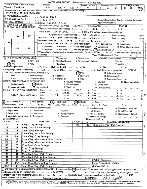
Specific Water Well Detail |
|
|
| Location Info | |||
| Owner: Hi-Plains Coop | Status: Constructed | ||
| Location: T6S, R29W, Sec. 9, NW NE SW | County: Sheridan | ||
| Directions: Hi-Plains Coop, Selden | |||
| Latitude: 39.5449544 | Longitude: -100.5653997 | Datum NAD 27 | |
| Latitude: 39.5449583 | Longitude: -100.5658216 | Datum NAD 83 | |
| Longitude and latitude calculated by Survey from township-range-section-quarter calls. Only good to within the quarter call accuracy. | |||
| View well on interactive map | |||
| General Info | ||
| Well Depth: 139.5 ft. | Elevation: 2835.61 ft. | |
| Static Water Level: ft. | Est. Yield: gpm. | |
| Comp. Date: 20-Dec-2001 | Well Use: Monitoring well/observation/piezometer | |
| DWR Applic. #: | Other ID: MW B 2 | |
| Driller Info | ||
| Driller: GeoCore, Inc. | License #: 527 | |
| Scanned Form | View scan |
|
Chemical Sample Submitted?:
Water Well disinfected?: | ||
| Casing Info | ||
| Casing Type:
Casing Joints: |
Diam: in. to ft | |
| Casing height above land surface: in
Casing Weight: lbs/ft Wall thickness or gauge no.: | ||
| Screen and Perforation Info | ||
| Screen Type: | Screen Openings: | |
| Screen-perforated intervals | From: ft to ft | |
| Gravel pack intervals | From: ft to ft | |
| Grout Info | ||
| Grout used: | From: to ft | |
| Source of Possible Contamination | ||
| Source: | ||
| Direction from well: | Distance: ft | |
| Lithologic Log
(Log data entered by KGS.) | ||
| From: 0 ft. to 20 ft. | Clay, gray orange | |
| From: 20 ft. to 30 ft. | Clay, dark yellow orange | |
| From: 30 ft. to 35 ft. | Sand, gray orange | |
| From: 35 ft. to 50 ft. | Sand clay, very pale orange | |
| From: 50 ft. to 80 ft. | Sand clay, gray orange | |
| From: 80 ft. to 100 ft. | Sand clay, moderate yellow brown | |
| From: 100 ft. to 115 ft. | Sand clay, moderate yellow brown | |
| From: 115 ft. to 120 ft. | Clay sand, gray orange | |
| From: 120 ft. to 123 ft. | Sand, gray orange | |
| From: 123 ft. to 130 ft. | Sand, gray orange | |
| From: 130 ft. to 131 ft. | Clay sand, very pale orange | |
| From: 131 ft. to 132 ft. | Clay sand, pale yellow brown | |
| From: 132 ft. to 133 ft. | Clay sand, very pale orange | |
| From: 133 ft. to 135.5 ft. | Sand clay, dark yellow orange | |
| From: 135.5 ft. to 140 ft. | Sand clay, very pale orange | |
| From: 140 ft. to 143 ft. | Sand clay, very pale orange | |