|
|
|
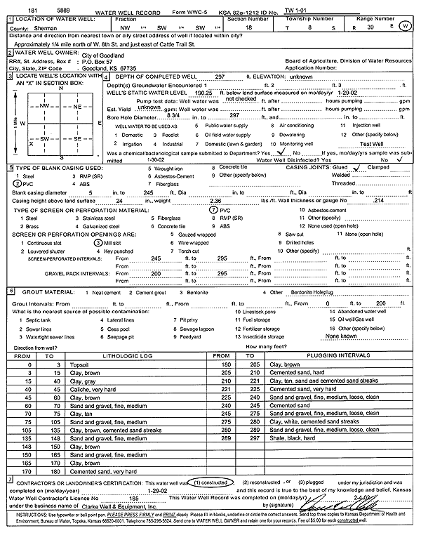
Specific Water Well Detail |
|
|
| Location Info | |||
| Owner: City of Goodland | Status: Constructed | ||
| Location: T8S, R39W, Sec. 18, NW SW SW | County: Sherman | ||
| Directions: .25 mi N of W 8th St, E of Cattle Trail St, Goodland | |||
| Latitude: 39.3538987 | Longitude: -101.72422 | Datum NAD 27 | |
| Latitude: 39.3538982 | Longitude: -101.7246705 | Datum NAD 83 | |
| Longitude and latitude calculated by Survey from township-range-section-quarter calls. Only good to within the quarter call accuracy. | |||
| View well on interactive map | |||
| General Info | ||
| Well Depth: 297 ft. | Elevation: ft. | |
| Static Water Level: 190.3 ft. | Est. Yield: gpm. | |
| Comp. Date: 29-Jan-2002 | Well Use: Test hole/well | |
| DWR Applic. #: | Other ID: TW 1-01 | |
| Driller Info | ||
| Driller: Clarke Well and Equipment, Inc. | License #: 185 | |
| Scanned Form | View scan |
|
Chemical Sample Submitted?:
Water Well disinfected?: | ||
| Casing Info | ||
| Casing Type:
Casing Joints: |
Diam: in. to ft | |
| Casing height above land surface: in
Casing Weight: lbs/ft Wall thickness or gauge no.: | ||
| Screen and Perforation Info | ||
| Screen Type: | Screen Openings: | |
| Screen-perforated intervals | From: ft to ft | |
| Gravel pack intervals | From: ft to ft | |
| Grout Info | ||
| Grout used: | From: to ft | |
| Source of Possible Contamination | ||
| Source: | ||
| Direction from well: | Distance: ft | |
| Lithologic Log
(Log data entered by KGS.) | ||
| From: 0 ft. to 3 ft. | Top soil | |
| From: 3 ft. to 15 ft. | Clay, brown | |
| From: 15 ft. to 40 ft. | Clay, gray | |
| From: 40 ft. to 45 ft. | Caliche, very hard | |
| From: 45 ft. to 60 ft. | Clay, brown | |
| From: 60 ft. to 70 ft. | Sand and gravel, fine, medium | |
| From: 70 ft. to 75 ft. | Clay, tan | |
| From: 75 ft. to 105 ft. | Sand and gravel, fine, medium | |
| From: 105 ft. to 135 ft. | Clay, brown, cemented sand streaks | |
| From: 135 ft. to 148 ft. | Sand and gravel, fine, medium | |
| From: 148 ft. to 150 ft. | Clay, brown | |
| From: 150 ft. to 165 ft. | Sand and gravel, fine, medium | |
| From: 165 ft. to 170 ft. | Clay, brown | |
| From: 170 ft. to 180 ft. | Cemented sand, very hard | |
| From: 180 ft. to 205 ft. | Clay, brown | |
| From: 205 ft. to 210 ft. | Cemented sand, hard | |
| From: 210 ft. to 221 ft. | Clay, tan, sand and cemented sand streaks | |
| From: 221 ft. to 225 ft. | Cemented sand, very hard | |
| From: 225 ft. to 240 ft. | Sand and gravel, fine, medium, loose, clean | |
| From: 240 ft. to 245 ft. | Cemented sand | |
| From: 245 ft. to 275 ft. | Sand and gravel, fine, medium, loose, clean | |
| From: 275 ft. to 280 ft. | Clay, white, cemented sand streaks | |
| From: 280 ft. to 289 ft. | Sand and gravel, fine, medium, loose, clean | |
| From: 289 ft. to 297 ft. | Shale, black, hard | |