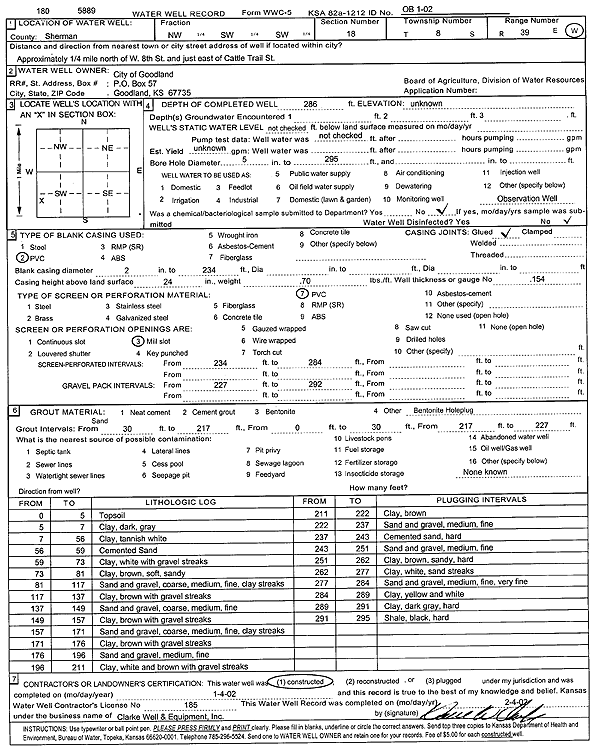
![]() |
![]() |
Specific Water Well Detail |
![]() |
Location Info | |||
Owner: City of Goodland | Status: Constructed | ||
Location: T8S, R39W, Sec. 18, NW SW SW | County: Sherman | ||
Directions: .25 mi N of W 8th St, E of Cattle Trail St., Goodland | |||
Latitude: 39.3538987 | Longitude: -101.72422 | Datum NAD 27 | |
Latitude: 39.3538982 | Longitude: -101.7246705 | Datum NAD 83 | |
Longitude and latitude calculated by Survey from township-range-section-quarter calls. Only good to within the quarter call accuracy. | |||
View well on interactive map This link will create a new window and display an interactive map of this well and its neighbors. |
General Info | ||
Well Depth: 286 ft. | Elevation: ft. | |
Static Water Level: ft. | Est. Yield: gpm. | |
Comp. Date: 04-Jan-2002 | Well Use: Monitoring well/observation/piezometer | |
DWR Applic. #: | Other ID: OB 1-02 |
Driller Info | ||
Driller: Clarke Well and Equipment, Inc. | License #: 185 |
Scanned Form | ||
View form(s) on screen | Download scan(s) | |
The download files contain one or more TIFF images compressed into a ZIP archive. Your browser may be already set up to decompress these files. The TIFFs are 300 dpi archival-quality scans of the WWC5 forms and can be viewed by software like Adobe PhotoShop. |
Chemical Sample Submitted?:
Water Well disinfected?: | ||
Casing Info | ||
Casing Type:
Casing Joints: |
Diam: in. to ft | |
Casing height above land surface: in
Casing Weight: lbs/ft Wall thickness or gauge no.: |
Screen and Perforation Info | ||
Screen Type: | Screen Openings: | |
Screen-perforated intervals | From: ft to ft | |
Gravel pack intervals | From: ft to ft |
Grout Info | ||
Grout used: | From: to ft |
Source of Possible Contamination | ||
Source: | ||
Direction from well: | Distance: ft |
Lithologic Log
(Log data entered by KGS.) | ||
From: 0 ft. to 5 ft. | Top soil | |
From: 5 ft. to 7 ft. | Clay, dark gray | |
From: 7 ft. to 56 ft. | Clay, tannish white | |
From: 56 ft. to 59 ft. | Cemented sand | |
From: 59 ft. to 73 ft. | Clay, white, with gravel streaks | |
From: 73 ft. to 81 ft. | Clay, brown, soft, sandy | |
From: 81 ft. to 117 ft. | Sand and gravel, coarse, medium, fine, clay streaks | |
From: 117 ft. to 137 ft. | Clay, brown, with gravel streaks | |
From: 137 ft. to 149 ft. | Sand and gravel, coarse, medium, fine | |
From: 149 ft. to 157 ft. | Clay, brown with gravel streaks | |
From: 157 ft. to 171 ft. | Sand and gravel, coarse, medium, fine, clay streaks | |
From: 171 ft. to 176 ft. | Clay, brown with gravel streaks | |
From: 176 ft. to 196 ft. | Sand and gravel, medium, fine | |
From: 196 ft. to 211 ft. | Clay, white and brown, with gravel streaks | |
From: 211 ft. to 222 ft. | Clay, brown | |
From: 222 ft. to 237 ft. | Sand and gravel, medium, fine | |
From: 237 ft. to 243 ft. | Cemented sand, hard | |
From: 243 ft. to 251 ft. | Sand and gravel, medium, fine | |
From: 251 ft. to 262 ft. | Clay, brown, sandy, hard | |
From: 262 ft. to 277 ft. | Clay, white, sand streaks | |
From: 277 ft. to 284 ft. | Sand and gravel, medium, fine, very fine | |
From: 284 ft. to 289 ft. | Clay, yellow and white | |
From: 289 ft. to 291 ft. | Clay, dark gray, hard | |
From: 291 ft. to 295 ft. | Shale, black, hard |