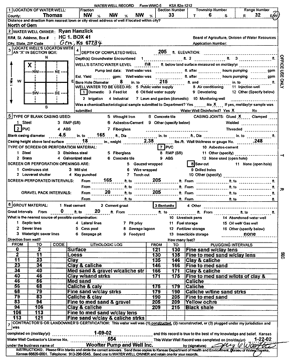
![]() |
![]() |
Specific Water Well Detail |
![]() |
Location Info | |||
Owner: Hanzlick, Ryan | Status: Constructed | ||
Location: T6S, R32W, Sec. 33, NW NW NW | County: Thomas | ||
Directions: N of Gem | |||
Latitude: 39.4950202 | Longitude: -100.9050463 | Datum NAD 27 | |
Latitude: 39.4950235 | Longitude: -100.9054763 | Datum NAD 83 | |
Longitude and latitude calculated by Survey from township-range-section-quarter calls. Only good to within the quarter call accuracy. | |||
View well on interactive map |
General Info | ||
Well Depth: 205 ft. | Elevation: ft. | |
Static Water Level: ft. | Est. Yield: gpm. | |
Comp. Date: 09-Jan-2002 | Well Use: Domestic | |
DWR Applic. #: | Other ID: |
Driller Info | ||
Driller: Jay C. Woofter Pump & Well, Inc. | License #: 554 |
Scanned Form | ||
View form(s) on screen | Download scan(s) | |
The download files contain one or more TIFF images compressed into a ZIP archive. Your browser may be already set up to decompress these files. The TIFFs are 300 dpi archival-quality scans of the WWC5 forms and can be viewed by software like Adobe PhotoShop. |
Chemical Sample Submitted?:
Water Well disinfected?: | ||
Casing Info | ||
Casing Type:
Casing Joints: |
Diam: in. to ft | |
Casing height above land surface: in
Casing Weight: lbs/ft Wall thickness or gauge no.: |
Screen and Perforation Info | ||
Screen Type: | Screen Openings: | |
Screen-perforated intervals | From: ft to ft | |
Gravel pack intervals | From: ft to ft |
Grout Info | ||
Grout used: | From: to ft |
Source of Possible Contamination | ||
Source: | ||
Direction from well: | Distance: ft |
Lithologic Log
(Log data entered by KGS.) | ||
From: 0 ft. to 2 ft. | Surface | |
From: 2 ft. to 11 ft. | Loess | |
From: 11 ft. to 23 ft. | Clay | |
From: 23 ft. to 34 ft. | Clay and caliche | |
From: 34 ft. to 40 ft. | Medium sand and gravel with caliche streak | |
From: 40 ft. to 46 ft. | Clay with sand streak | |
From: 46 ft. to 56 ft. | Medium sand | |
From: 56 ft. to 68 ft. | Caliche and clay | |
From: 68 ft. to 79 ft. | Fine sand with clay streaks | |
From: 79 ft. to 83 ft. | Caliche and clay | |
From: 83 ft. to 94 ft. | Fine to medium sand and gravel | |
From: 94 ft. to 106 ft. | Clay and caliche | |
From: 106 ft. to 113 ft. | Fine to medium sand with clay lens | |
From: 113 ft. to 121 ft. | Fine sand with clay and caliche streaks | |
From: 121 ft. to 130 ft. | Fine sand with clay lens | |
From: 130 ft. to 135 ft. | Fine to medium sand with clay lens | |
From: 135 ft. to 146 ft. | Clay and caliche | |
From: 146 ft. to 166 ft. | Fine to medium sand | |
From: 166 ft. to 171 ft. | Clay and caliche | |
From: 171 ft. to 175 ft. | Fine to medium sand with lots of clay and caliche | |
From: 175 ft. to 179 ft. | Caliche | |
From: 179 ft. to 190 ft. | Caliche with fine sand streaks | |
From: 190 ft. to 205 ft. | Fine to medium sand | |
From: 205 ft. to 209 ft. | Yellow ochre | |
From: 209 ft. to 215 ft. | Black shale |