|
|
|
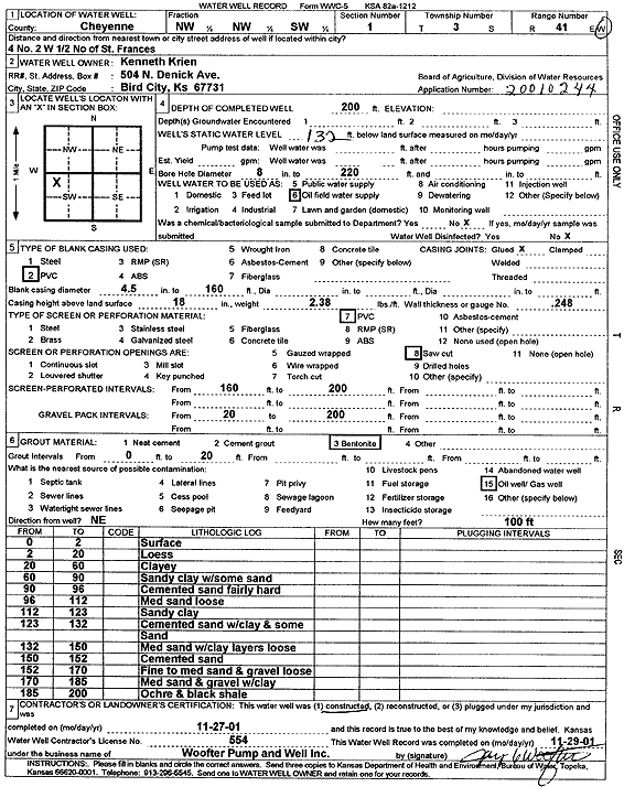
Specific Water Well Detail |
|
|
| Location Info | |||
| Owner: Krien, Kenneth | Status: Constructed | ||
| Location: T3S, R41W, Sec. 1, NW NW SW | County: Cheyenne | ||
| Directions: from St. Francis: 4 mi N, 2 mi W, .5 mi N | |||
| Latitude: 39.8210412 | Longitude: -101.8788669 | Datum NAD 27 | |
| Latitude: 39.8210338 | Longitude: -101.8793231 | Datum NAD 83 | |
| Longitude and latitude calculated by Survey from township-range-section-quarter calls. Only good to within the quarter call accuracy. | |||
| View well on interactive map | |||
| General Info | ||
| Well Depth: 200 ft. | Elevation: ft. | |
| Static Water Level: 132 ft. | Est. Yield: gpm. | |
| Comp. Date: 27-Nov-2001 | Well Use: Oil Field Water Supply | |
| DWR Applic. #: 20010244 | Other ID: | |
| Links | |
| No Wizard information available. | |
| View info from WIMAS Water Right Data base... | |
| Driller Info | ||
| Driller: Jay C. Woofter Pump & Well, Inc. | License #: 554 | |
| Scanned Form | View scan |
|
Chemical Sample Submitted?:
Water Well disinfected?: | ||
| Casing Info | ||
| Casing Type:
Casing Joints: |
Diam: in. to ft | |
| Casing height above land surface: in
Casing Weight: lbs/ft Wall thickness or gauge no.: | ||
| Screen and Perforation Info | ||
| Screen Type: | Screen Openings: | |
| Screen-perforated intervals | From: ft to ft | |
| Gravel pack intervals | From: ft to ft | |
| Grout Info | ||
| Grout used: | From: to ft | |
| Source of Possible Contamination | ||
| Source: | ||
| Direction from well: | Distance: ft | |
| Lithologic Log
(Log data entered by KGS.) | ||
| From: 0 ft. to 2 ft. | Surface | |
| From: 2 ft. to 20 ft. | Loess | |
| From: 20 ft. to 60 ft. | Clayey | |
| From: 60 ft. to 90 ft. | Sandy clay with some sand | |
| From: 90 ft. to 96 ft. | Cemented sand fairly hard | |
| From: 96 ft. to 112 ft. | Medium sand loose | |
| From: 112 ft. to 123 ft. | Sandy clay | |
| From: 123 ft. to 132 ft. | Cemented sand with clay and some sand | |
| From: 132 ft. to 150 ft. | Medium sand with clay layers loose | |
| From: 150 ft. to 152 ft. | Cemented sand | |
| From: 152 ft. to 170 ft. | Fine to medium sand and gravel loose | |
| From: 170 ft. to 185 ft. | Medium sand and gravel with clay | |
| From: 185 ft. to 200 ft. | Ochre and black shale | |