|
|
|
Specific Water Well Detail |
|
|
| Location Info | |||
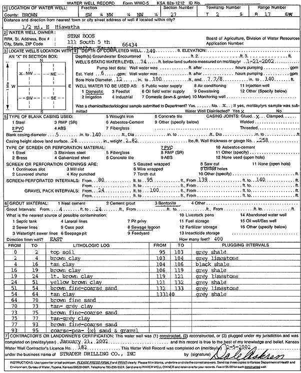
| Owner: Boos, Stan | Status: Constructed | ||
| Location: T2S, R17E, Sec. 27, SW NW NW | County: Brown | ||
| Directions: from Hiawatha: .5 mi E | |||
| Latitude: 39.8532075 | Longitude: -95.5069335 | Datum NAD 27 | |
| Latitude: 39.8532114 | Longitude: -95.5071929 | Datum NAD 83 | |
| Longitude and latitude calculated by Survey from township-range-section-quarter calls. Only good to within the quarter call accuracy. | |||
| View well on interactive map | |||
| General Info | ||
| Well Depth: 140 ft. | Elevation: ft. | |
| Static Water Level: 74 ft. | Est. Yield: 6 gpm. | |
| Comp. Date: 21-Jan-2002 | Well Use: Domestic | |
| DWR Applic. #: | Other ID: | |
| Driller Info | ||
| Driller: Strader Drilling Co., Inc. | License #: 182 | |
| Scanned Form | View scan |
|
Chemical Sample Submitted?:
Water Well disinfected?: | ||
| Casing Info | ||
| Casing Type:
Casing Joints: |
Diam: in. to ft | |
| Casing height above land surface: in
Casing Weight: lbs/ft Wall thickness or gauge no.: | ||
| Screen and Perforation Info | ||
| Screen Type: | Screen Openings: | |
| Screen-perforated intervals | From: ft to ft | |
| Gravel pack intervals | From: ft to ft | |
| Grout Info | ||
| Grout used: | From: to ft | |
| Source of Possible Contamination | ||
| Source: | ||
| Direction from well: | Distance: ft | |
| Lithologic Log
(Log data entered by KGS.) | ||
| From: 0 ft. to 2 ft. | Topsoil | |
| From: 2 ft. to 4 ft. | Brown clay | |
| From: 4 ft. to 16 ft. | Tan clay | |
| From: 16 ft. to 19 ft. | Brown clay | |
| From: 19 ft. to 24 ft. | Light brown clay | |
| From: 24 ft. to 51 ft. | Yellow brown clay | |
| From: 51 ft. to 54 ft. | Yellow brown clay | |
| From: 54 ft. to 64 ft. | Tan clay | |
| From: 64 ft. to 70 ft. | Brown fine sand | |
| From: 70 ft. to 73 ft. | Tan-gray clay | |
| From: 73 ft. to 75 ft. | Brown fine-coarse sand | |
| From: 75 ft. to 77 ft. | Tan-gray clay | |
| From: 77 ft. to 93 ft. | Brown fine-coarse sand | |
| From: 93 ft. to 95 ft. | Coarse, pea gravel (1/4 x 1/2 inch), sand and gravel | |
| From: 95 ft. to 103 ft. | Gray shale | |
| From: 103 ft. to 104 ft. | Gray limestone | |
| From: 104 ft. to 106 ft. | Black shale | |
| From: 106 ft. to 119 ft. | Gray shale | |
| From: 119 ft. to 121 ft. | Gray limestone | |
| From: 121 ft. to 132 ft. | Gray shale | |
| From: 132 ft. to 133 ft. | Gray limestone | |
| From: 133 ft. to 140 ft. | Gray shale | |