|
|
|
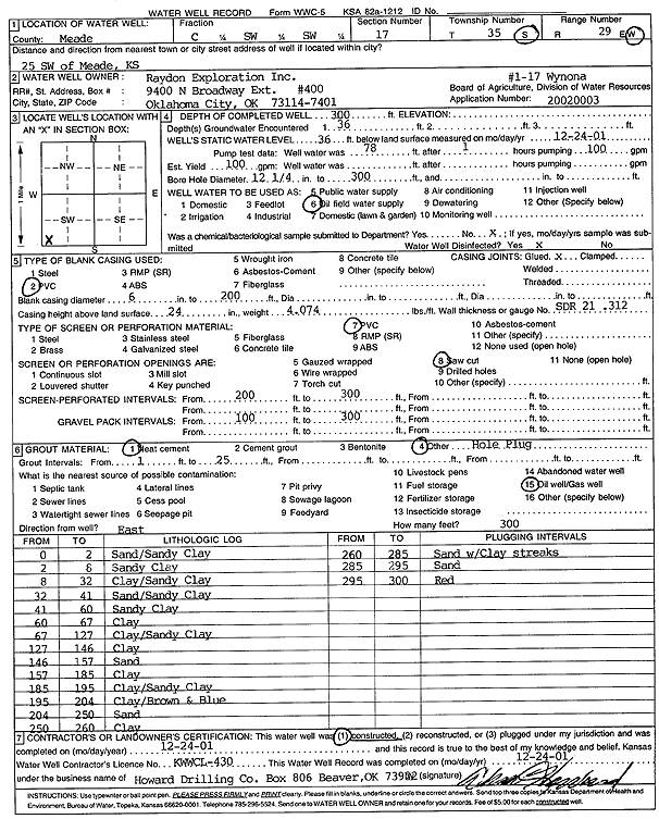
Specific Water Well Detail |
|
|
| Location Info | |||
| Owner: Raydon Exploration Co., Inc. | Status: Constructed | ||
| Location: T35S, R29W, Sec. 17, C SW SW | County: Meade | ||
| Directions: from Meade: 25 mi SW | |||
| Latitude: 37.0020488 | Longitude: -100.5033902 | Datum NAD 27 | |
| Latitude: 37.0020749 | Longitude: -100.503819 | Datum NAD 83 | |
| Longitude and latitude calculated by Survey from township-range-section-quarter calls. Only good to within the quarter call accuracy. | |||
| View well on interactive map | |||
| General Info | ||
| Well Depth: 300 ft. | Elevation: ft. | |
| Static Water Level: 36 ft. | Est. Yield: 100 gpm. | |
| Comp. Date: 24-Dec-2001 | Well Use: Oil Field Water Supply | |
| DWR Applic. #: 20020003 | Other ID: 1-17 Wynona | |
| Driller Info | ||
| Driller: Howard Drilling Company AG, LLC | License #: 430 | |
| Scanned Form | View scan |
|
Chemical Sample Submitted?:
Water Well disinfected?: | ||
| Casing Info | ||
| Casing Type:
Casing Joints: |
Diam: in. to ft | |
| Casing height above land surface: in
Casing Weight: lbs/ft Wall thickness or gauge no.: | ||
| Screen and Perforation Info | ||
| Screen Type: | Screen Openings: | |
| Screen-perforated intervals | From: ft to ft | |
| Gravel pack intervals | From: ft to ft | |
| Grout Info | ||
| Grout used: | From: to ft | |
| Source of Possible Contamination | ||
| Source: | ||
| Direction from well: | Distance: ft | |
| Lithologic Log
(Log data entered by KGS.) | ||
| From: 0 ft. to 2 ft. | sand and sandy clay | |
| From: 2 ft. to 8 ft. | sandy clay | |
| From: 8 ft. to 32 ft. | clay and sandy clay | |
| From: 32 ft. to 41 ft. | sand and sandy clay | |
| From: 41 ft. to 60 ft. | sandy clay | |
| From: 60 ft. to 67 ft. | clay | |
| From: 67 ft. to 127 ft. | clay and sandy clay | |
| From: 127 ft. to 146 ft. | clay | |
| From: 146 ft. to 157 ft. | sand | |
| From: 157 ft. to 185 ft. | clay | |
| From: 185 ft. to 195 ft. | clay and sandy clay | |
| From: 195 ft. to 204 ft. | clay and brown and blue | |
| From: 204 ft. to 250 ft. | sand | |
| From: 250 ft. to 260 ft. | clay | |
| From: 260 ft. to 285 ft. | sand with clay streaks | |
| From: 285 ft. to 295 ft. | sand | |
| From: 295 ft. to 300 ft. | red | |