|
|
|
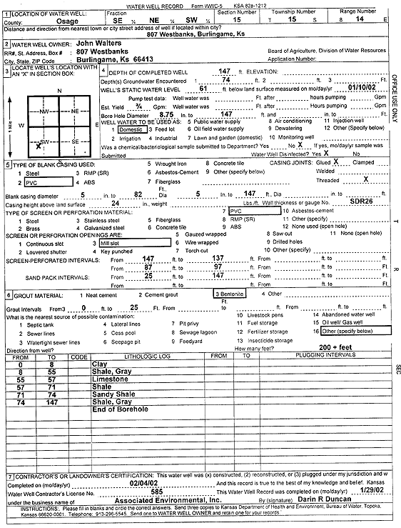
Specific Water Well Detail |
|
|
| Location Info | |||
| Owner: Walters, John | Status: Constructed | ||
| Location: T15S, R14E, Sec. 15, SE NE SW | County: Osage | ||
| Directions: 807 Westbanks, Burlingame (WW281) | |||
| Latitude: 38.7436464 | Longitude: -95.8448262 | Datum NAD 27 | |
| Latitude: 38.7436526 | Longitude: -95.8450912 | Datum NAD 83 | |
| Longitude and latitude calculated by Survey from township-range-section-quarter calls. Only good to within the quarter call accuracy. | |||
| View well on interactive map | |||
| General Info | ||
| Well Depth: 147 ft. | Elevation: ft. | |
| Static Water Level: 61 ft. | Est. Yield: .75 gpm. | |
| Comp. Date: 04-Feb-2002 | Well Use: Domestic | |
| DWR Applic. #: | Other ID: | |
| Driller Info | ||
| Driller: Associated Environmental, Inc. | License #: 585 | |
| Scanned Form | View scan |
|
Chemical Sample Submitted?:
Water Well disinfected?: | ||
| Casing Info | ||
| Casing Type:
Casing Joints: |
Diam: in. to ft | |
| Casing height above land surface: in
Casing Weight: lbs/ft Wall thickness or gauge no.: | ||
| Screen and Perforation Info | ||
| Screen Type: | Screen Openings: | |
| Screen-perforated intervals | From: ft to ft | |
| Gravel pack intervals | From: ft to ft | |
| Grout Info | ||
| Grout used: | From: to ft | |
| Source of Possible Contamination | ||
| Source: | ||
| Direction from well: | Distance: ft | |
| Lithologic Log
(Log data entered by KGS.) | ||
| From: 0 ft. to 8 ft. | clay | |
| From: 8 ft. to 55 ft. | shale, gray | |
| From: 55 ft. to 57 ft. | limestone | |
| From: 57 ft. to 71 ft. | shale | |
| From: 71 ft. to 74 ft. | sandy shale | |
| From: 74 ft. to 147 ft. | shale, gray | |