|
|
|
Specific Water Well Detail |
|
|
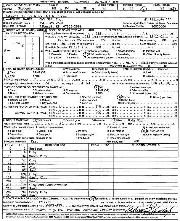
| Location Info | |||
| Owner: Oxy USA, Inc. | Status: Constructed | ||
| Location: T34S, R35W, Sec. 20, NW SW NE | County: Stevens | ||
| Directions: from Liberal: 12.5 mi W, .75 mi N | |||
| Latitude: 37.0785111 | Longitude: -101.1471557 | Datum NAD 27 | |
| Latitude: 37.0785368 | Longitude: -101.1475969 | Datum NAD 83 | |
| Longitude and latitude calculated by Survey from township-range-section-quarter calls. Only good to within the quarter call accuracy. | |||
| View well on interactive map | |||
| General Info | ||
| Well Depth: 400 ft. | Elevation: ft. | |
| Static Water Level: 235 ft. | Est. Yield: 80 gpm. | |
| Comp. Date: 12-Dec-2001 | Well Use: Oil Field Water Supply | |
| DWR Applic. #: 20020006 | Other ID: Illinois A-1 | |
| Links | |
| No Wizard information available. | |
| View info from WIMAS Water Right Data base... | |
| Driller Info | ||
| Driller: Howard Drilling Company AG, LLC | License #: 430 | |
| Scanned Form | View scan |
|
Chemical Sample Submitted?:
Water Well disinfected?: | ||
| Casing Info | ||
| Casing Type:
Casing Joints: |
Diam: in. to ft | |
| Casing height above land surface: in
Casing Weight: lbs/ft Wall thickness or gauge no.: | ||
| Screen and Perforation Info | ||
| Screen Type: | Screen Openings: | |
| Screen-perforated intervals | From: ft to ft | |
| Gravel pack intervals | From: ft to ft | |
| Grout Info | ||
| Grout used: | From: to ft | |
| Source of Possible Contamination | ||
| Source: | ||
| Direction from well: | Distance: ft | |
| Lithologic Log
(Log data entered by KGS.) | ||
| From: 0 ft. to 1 ft. | surface | |
| From: 1 ft. to 16 ft. | clay | |
| From: 16 ft. to 34 ft. | sandy clay | |
| From: 34 ft. to 51 ft. | clay | |
| From: 51 ft. to 63 ft. | sand | |
| From: 63 ft. to 71 ft. | clay | |
| From: 71 ft. to 93 ft. | sand | |
| From: 93 ft. to 128 ft. | clay | |
| From: 128 ft. to 204 ft. | sandy clay | |
| From: 204 ft. to 211 ft. | sand | |
| From: 211 ft. to 219 ft. | clay and sand streaks | |
| From: 219 ft. to 287 ft. | sand | |
| From: 287 ft. to 294 ft. | sandy clay | |
| From: 294 ft. to 400 ft. | sand | |