|
|
|
Specific Water Well Detail |
|
|
| Location Info | |||
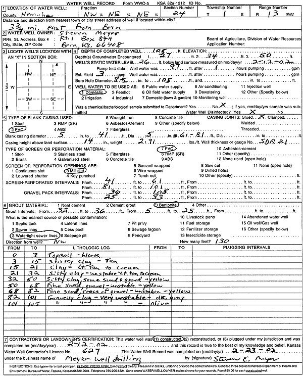
| Owner: Meyer, Steven | Status: Constructed | ||
| Location: T1S, R13E, Sec. 24, NW NE NE | County: Nemaha | ||
| Directions: from Bern: 3.75 mi E | |||
| Latitude: 39.9561279 | Longitude: -95.9051909 | Datum NAD 27 | |
| Latitude: 39.956128 | Longitude: -95.9054633 | Datum NAD 83 | |
| Longitude and latitude calculated by Survey from township-range-section-quarter calls. Only good to within the quarter call accuracy. | |||
| View well on interactive map | |||
| General Info | ||
| Well Depth: 105 ft. | Elevation: ft. | |
| Static Water Level: 26 ft. | Est. Yield: 3 gpm. | |
| Comp. Date: 12-Feb-2002 | Well Use: Domestic | |
| DWR Applic. #: | Other ID: | |
| Driller Info | ||
| Driller: Meyer Well Drilling | License #: 627 | |
| Scanned Form | View scan |
|
Chemical Sample Submitted?:
Water Well disinfected?: | ||
| Casing Info | ||
| Casing Type:
Casing Joints: |
Diam: in. to ft | |
| Casing height above land surface: in
Casing Weight: lbs/ft Wall thickness or gauge no.: | ||
| Screen and Perforation Info | ||
| Screen Type: | Screen Openings: | |
| Screen-perforated intervals | From: ft to ft | |
| Gravel pack intervals | From: ft to ft | |
| Grout Info | ||
| Grout used: | From: to ft | |
| Source of Possible Contamination | ||
| Source: | ||
| Direction from well: | Distance: ft | |
| Lithologic Log
(Log data entered by KGS.) | ||
| From: 0 ft. to 3 ft. | Topsoil, black | |
| From: 3 ft. to 15 ft. | Sticky clay, tan | |
| From: 15 ft. to 21 ft. | Clay, light tan to cream | |
| From: 21 ft. to 32 ft. | Silty clay, unstable, light tan to cream | |
| From: 32 ft. to 50 ft. | Silty clay, some sand and gravel, yellow | |
| From: 50 ft. to 68 ft. | Fine sand, gravel, unstable, yellow | |
| From: 68 ft. to 82 ft. | Fine sand, trace of gravel, unstable, yellow | |
| From: 82 ft. to 101 ft. | Gravelly clay, very unstable, dark gray | |
| From: 101 ft. to 105 ft. | Gravelly clay, very unstable, olive | |