|
|
|
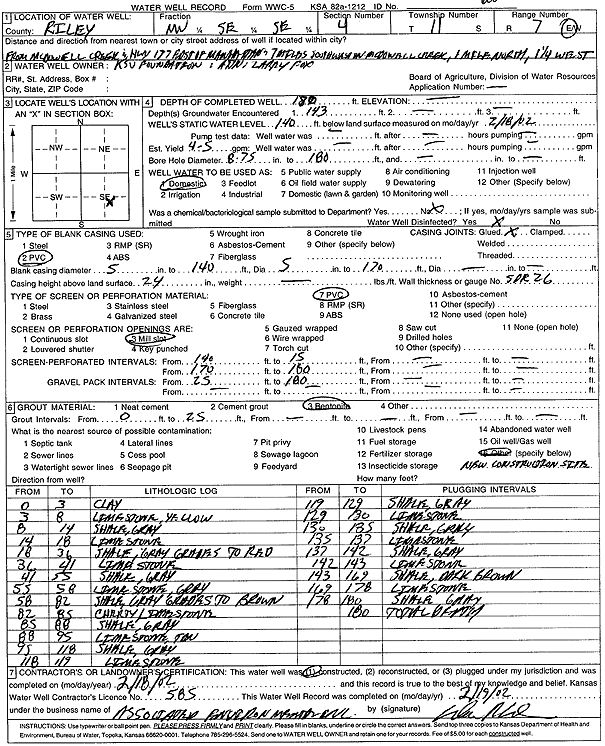
Specific Water Well Detail |
|
|
| Location Info | |||
| Owner: KSU Foundation | Status: Constructed | ||
| Location: T11S, R7E, Sec. 4, NW SE SE | County: Riley | ||
| Directions: from McDowell Creek and Hwy 77, Manhattan: 7 mi SW, 1 mi N, 1.25 mi W | |||
| Latitude: 39.1194691 | Longitude: -96.6559024 | Datum NAD 27 | |
| Latitude: 39.1194667 | Longitude: -96.6561849 | Datum NAD 83 | |
| Longitude and latitude calculated by Survey from township-range-section-quarter calls. Only good to within the quarter call accuracy. | |||
| View well on interactive map | |||
| General Info | ||
| Well Depth: 180 ft. | Elevation: ft. | |
| Static Water Level: 140 ft. | Est. Yield: 4.5 gpm. | |
| Comp. Date: 18-Feb-2002 | Well Use: Domestic | |
| DWR Applic. #: | Other ID: | |
| Driller Info | ||
| Driller: Associated Environmental, Inc. | License #: 585 | |
| Scanned Form | View scan |
|
Chemical Sample Submitted?:
Water Well disinfected?: | ||
| Casing Info | ||
| Casing Type:
Casing Joints: |
Diam: in. to ft | |
| Casing height above land surface: in
Casing Weight: lbs/ft Wall thickness or gauge no.: | ||
| Screen and Perforation Info | ||
| Screen Type: | Screen Openings: | |
| Screen-perforated intervals | From: ft to ft | |
| Gravel pack intervals | From: ft to ft | |
| Grout Info | ||
| Grout used: | From: to ft | |
| Source of Possible Contamination | ||
| Source: | ||
| Direction from well: | Distance: ft | |
| Lithologic Log
(Log data entered by KGS.) | ||
| From: 0 ft. to 3 ft. | clay | |
| From: 3 ft. to 8 ft. | limestone, yellow | |
| From: 8 ft. to 14 ft. | shale, gray | |
| From: 14 ft. to 18 ft. | limestone | |
| From: 18 ft. to 36 ft. | shale, gray grades to red | |
| From: 36 ft. to 41 ft. | limestone | |
| From: 41 ft. to 55 ft. | shale, gray | |
| From: 55 ft. to 58 ft. | limestone, gray | |
| From: 58 ft. to 82 ft. | shale, gray grades to brown | |
| From: 82 ft. to 85 ft. | cherty limestone | |
| From: 85 ft. to 88 ft. | shale, gray | |
| From: 88 ft. to 95 ft. | limestone, tan | |
| From: 95 ft. to 118 ft. | shale, gray | |
| From: 118 ft. to 119 ft. | limestone | |
| From: 119 ft. to 129 ft. | shale, gray | |
| From: 129 ft. to 130 ft. | limestone | |
| From: 130 ft. to 135 ft. | shale, gray | |
| From: 135 ft. to 137 ft. | limestone | |
| From: 137 ft. to 142 ft. | shale, gray | |
| From: 142 ft. to 143 ft. | limestone | |
| From: 143 ft. to 169 ft. | shale, dark brown | |
| From: 169 ft. to 178 ft. | limestone | |
| From: 178 ft. to 180 ft. | shale, gray | |