|
|
|
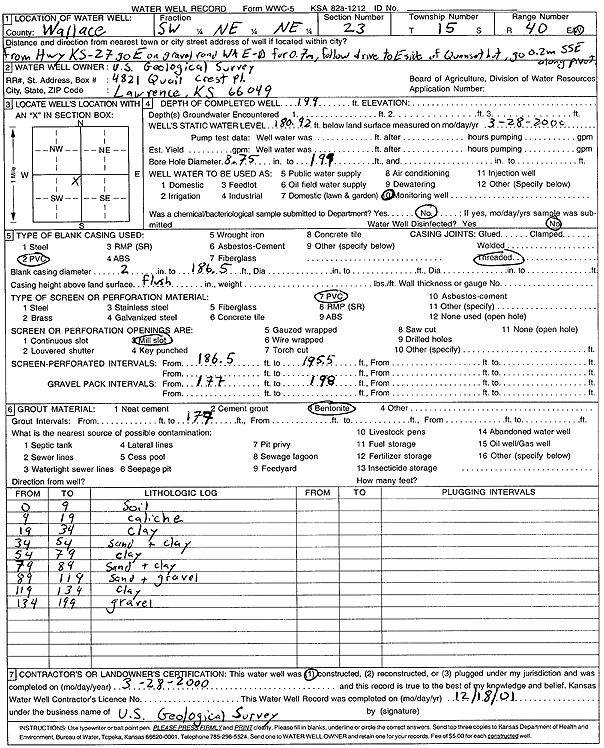
Specific Water Well Detail |
|
|
| Location Info | |||
| Owner: U.S. Geological Survey | Status: Constructed | ||
| Location: T15S, R40W, Sec. 23, SW NE NE | County: Wallace | ||
| Directions: from Hwy 27, .7 E on WAE-D, follow drive to East side of Quonset hut, .2 mi SSE along pivot | |||
| Latitude: 38.7393383 | Longitude: -101.7279253 | Datum NAD 27 | |
| Latitude: 38.7393505 | Longitude: -101.7283736 | Datum NAD 83 | |
| Longitude and latitude calculated by Survey from township-range-section-quarter calls. Only good to within the quarter call accuracy. | |||
| View well on interactive map | |||
| General Info | ||
| Well Depth: 199 ft. | Elevation: ft. | |
| Static Water Level: 180.92 ft. | Est. Yield: gpm. | |
| Comp. Date: 28-Mar-2000 | Well Use: Monitoring well/observation/piezometer | |
| DWR Applic. #: | Other ID: | |
| Driller Info | ||
| Driller: U.S. Geological Survey | License #: | |
| Scanned Form | View scan |
|
Chemical Sample Submitted?:
Water Well disinfected?: | ||
| Casing Info | ||
| Casing Type:
Casing Joints: |
Diam: in. to ft | |
| Casing height above land surface: in
Casing Weight: lbs/ft Wall thickness or gauge no.: | ||
| Screen and Perforation Info | ||
| Screen Type: | Screen Openings: | |
| Screen-perforated intervals | From: ft to ft | |
| Gravel pack intervals | From: ft to ft | |
| Grout Info | ||
| Grout used: | From: to ft | |
| Source of Possible Contamination | ||
| Source: | ||
| Direction from well: | Distance: ft | |
| Lithologic Log
(Log data entered by KGS.) | ||
| From: 0 ft. to 9 ft. | Soil | |
| From: 9 ft. to 19 ft. | Caliche | |
| From: 19 ft. to 34 ft. | Clay | |
| From: 34 ft. to 54 ft. | Sand and clay | |
| From: 54 ft. to 79 ft. | Clay | |
| From: 79 ft. to 89 ft. | Sand and clay | |
| From: 89 ft. to 119 ft. | Sand and gravel | |
| From: 119 ft. to 134 ft. | Clay | |
| From: 134 ft. to 199 ft. | Gravel | |