|
|
|
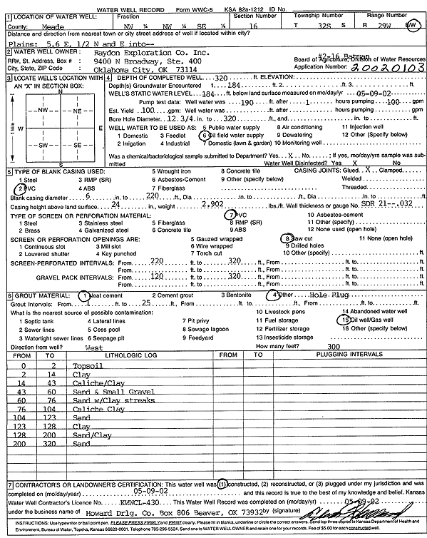
Specific Water Well Detail |
|
|
| Location Info | |||
| Owner: Raydon Exploration Co., Inc. | Status: Constructed | ||
| Location: T32S, R29W, Sec. 16, NW NW SE | County: Meade | ||
| Directions: from Plains: 5.6 mi E, .5 mi N, E into site | |||
| Latitude: 37.2629871 | Longitude: -100.4787173 | Datum NAD 27 | |
| Latitude: 37.2630101 | Longitude: -100.4791447 | Datum NAD 83 | |
| Longitude and latitude calculated by Survey from township-range-section-quarter calls. Only good to within the quarter call accuracy. | |||
| View well on interactive map | |||
| General Info | ||
| Well Depth: 320 ft. | Elevation: ft. | |
| Static Water Level: 184 ft. | Est. Yield: 100 gpm. | |
| Comp. Date: 09-May-2002 | Well Use: Oil Field Water Supply | |
| DWR Applic. #: 20020103 | Other ID: 2-16 Batman | |
| Links | |
| No Wizard information available. | |
| View info from WIMAS Water Right Data base... | |
| Driller Info | ||
| Driller: Howard Drilling Company AG, LLC | License #: 430 | |
| Scanned Form | View scan |
|
Chemical Sample Submitted?:
Water Well disinfected?: | ||
| Casing Info | ||
| Casing Type:
Casing Joints: |
Diam: in. to ft | |
| Casing height above land surface: in
Casing Weight: lbs/ft Wall thickness or gauge no.: | ||
| Screen and Perforation Info | ||
| Screen Type: | Screen Openings: | |
| Screen-perforated intervals | From: ft to ft | |
| Gravel pack intervals | From: ft to ft | |
| Grout Info | ||
| Grout used: | From: to ft | |
| Source of Possible Contamination | ||
| Source: | ||
| Direction from well: | Distance: ft | |
| Lithologic Log
(Log data entered by KGS.) | ||
| From: 0 ft. to 2 ft. | topsoil | |
| From: 2 ft. to 14 ft. | clay | |
| From: 14 ft. to 43 ft. | caliche/clay | |
| From: 43 ft. to 60 ft. | sand and small gravel | |
| From: 60 ft. to 76 ft. | sand with clay streaks | |
| From: 76 ft. to 104 ft. | caliche clay | |
| From: 104 ft. to 123 ft. | sand | |
| From: 123 ft. to 128 ft. | clay | |
| From: 128 ft. to 200 ft. | sand/clay | |
| From: 200 ft. to 320 ft. | sand | |