|
|
|
Specific Water Well Detail |
|
|
| Location Info | |||
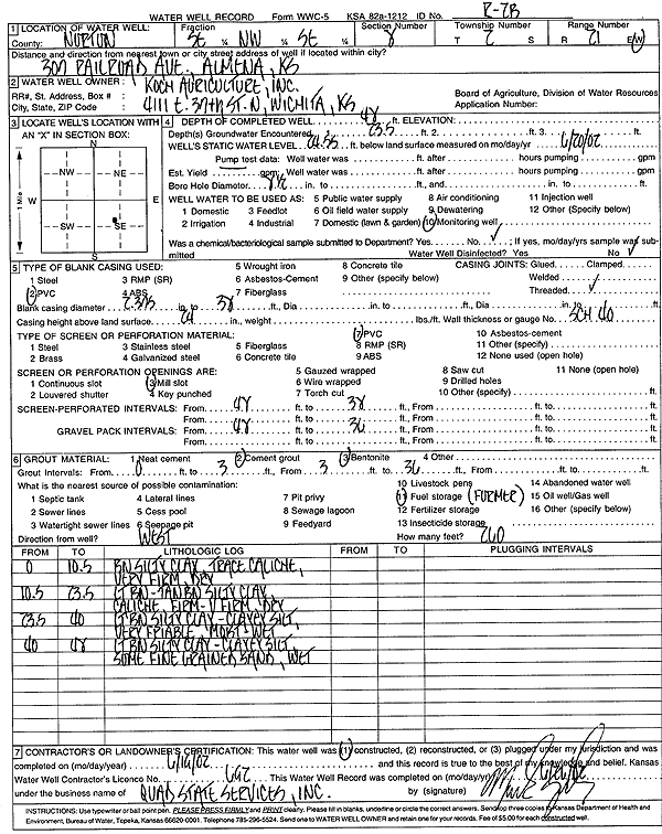
| Owner: Koch Agriculture, Inc. | Status: Constructed | ||
| Location: T2S, R21W, Sec. 8, SE NW SE | County: Norton | ||
| Directions: 307 Railroad Ave, Almena | |||
| Latitude: 39.890244 | Longitude: -99.7075299 | Datum NAD 27 | |
| Latitude: 39.8902512 | Longitude: -99.7079212 | Datum NAD 83 | |
| Longitude and latitude calculated by Survey from township-range-section-quarter calls. Only good to within the quarter call accuracy. | |||
| View well on interactive map | |||
| General Info | ||
| Well Depth: 48 ft. | Elevation: ft. | |
| Static Water Level: 24.55 ft. | Est. Yield: gpm. | |
| Comp. Date: 19-Jun-2002 | Well Use: Monitoring well/observation/piezometer | |
| DWR Applic. #: | Other ID: R-2B | |
| Driller Info | ||
| Driller: Quad State Services, Inc. | License #: 692 | |
| Scanned Form | View scan |
|
Chemical Sample Submitted?:
Water Well disinfected?: | ||
| Casing Info | ||
| Casing Type:
Casing Joints: |
Diam: in. to ft | |
| Casing height above land surface: in
Casing Weight: lbs/ft Wall thickness or gauge no.: | ||
| Screen and Perforation Info | ||
| Screen Type: | Screen Openings: | |
| Screen-perforated intervals | From: ft to ft | |
| Gravel pack intervals | From: ft to ft | |
| Grout Info | ||
| Grout used: | From: to ft | |
| Source of Possible Contamination | ||
| Source: | ||
| Direction from well: | Distance: ft | |
| Lithologic Log
(Log data entered by KGS.) | ||
| From: 0 ft. to 10.5 ft. | brown silty clay, trace caliche, very firm, dry | |
| From: 10.5 ft. to 23.5 ft. | light brown-tan brown silty clay, caliche firm-very firm, dry | |
| From: 23.5 ft. to 40 ft. | light brown silty clay, clayey silt, very friable, moist-wet | |
| From: 40 ft. to 48 ft. | light brown silty clay, clayey silt, some fine grained sand, wet | |