|
|
|
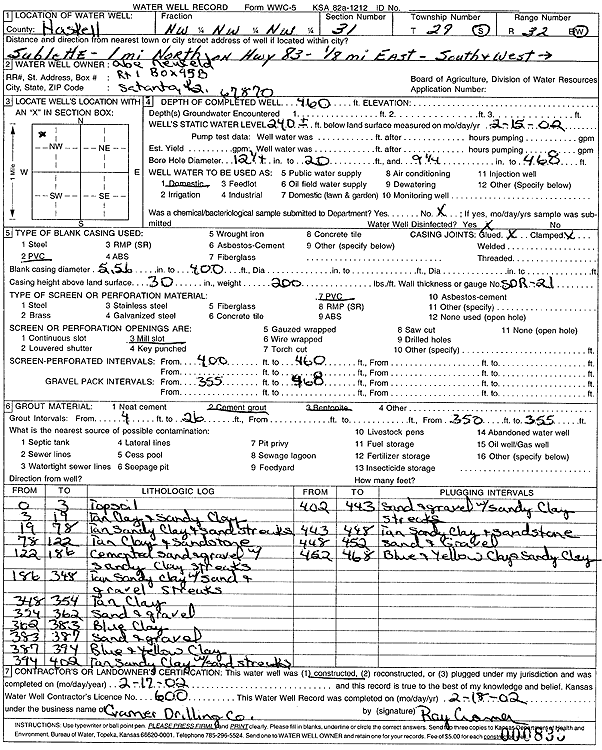
Specific Water Well Detail |
|
|
| Location Info | |||
| Owner: Neufeld, Abe | Status: Constructed | ||
| Location: T29S, R32W, Sec. 31, NW NW NW | County: Haskell | ||
| Directions: from Sublette: 1 mi North on Hwy 83, .13 mi East, South and West | |||
| Latitude: 37.4885884 | Longitude: -100.8694691 | Datum NAD 27 | |
| Latitude: 37.488613 | Longitude: -100.8699104 | Datum NAD 83 | |
| Longitude and latitude calculated by Survey from township-range-section-quarter calls. Only good to within the quarter call accuracy. | |||
| View well on interactive map | |||
| General Info | ||
| Well Depth: 460 ft. | Elevation: ft. | |
| Static Water Level: 240 ft. | Est. Yield: gpm. | |
| Comp. Date: 17-Feb-2002 | Well Use: Domestic | |
| DWR Applic. #: | Other ID: | |
| Driller Info | ||
| Driller: Ray Cramer Drilling Co. | License #: 600 | |
| Scanned Form | View scan |
|
Chemical Sample Submitted?:
Water Well disinfected?: | ||
| Casing Info | ||
| Casing Type:
Casing Joints: |
Diam: in. to ft | |
| Casing height above land surface: in
Casing Weight: lbs/ft Wall thickness or gauge no.: | ||
| Screen and Perforation Info | ||
| Screen Type: | Screen Openings: | |
| Screen-perforated intervals | From: ft to ft | |
| Gravel pack intervals | From: ft to ft | |
| Grout Info | ||
| Grout used: | From: to ft | |
| Source of Possible Contamination | ||
| Source: | ||
| Direction from well: | Distance: ft | |
| Lithologic Log
(Log data entered by KGS.) | ||
| From: 0 ft. to 3 ft. | topsoil | |
| From: 3 ft. to 19 ft. | tan clay + sandy clay | |
| From: 19 ft. to 78 ft. | tan sandy clay + sand streaks | |
| From: 78 ft. to 122 ft. | tan clay + sandstone | |
| From: 122 ft. to 186 ft. | cemented sand + gravel with sandy clay streaks | |
| From: 186 ft. to 348 ft. | tan sandy clay with sand + gravel streaks | |
| From: 348 ft. to 354 ft. | tan clay | |
| From: 354 ft. to 362 ft. | sand + gravel | |
| From: 362 ft. to 383 ft. | blue clay | |
| From: 383 ft. to 387 ft. | sand + gravel | |
| From: 387 ft. to 394 ft. | blue + yellow clay | |
| From: 394 ft. to 402 ft. | tan sandy clay with sand streaks | |
| From: 402 ft. to 443 ft. | sand + gravel with sandy clay streaks | |
| From: 443 ft. to 448 ft. | tan sandy clay + sandstone | |
| From: 448 ft. to 452 ft. | sand + gravel | |
| From: 452 ft. to 468 ft. | blue + yellow clay + sandy clay | |