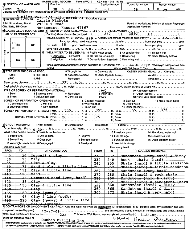
Lithologic Log
(Log data entered by KGS.) |
| |
From: 0 ft. to 30 ft. |
Topsoil and clay |
| |
From: 30 ft. to 55 ft. |
Clay |
| |
From: 55 ft. to 60 ft. |
Lime and clay |
| |
From: 60 ft. to 75 ft. |
Sand and clay and little lime |
| |
From: 75 ft. to 113 ft. |
Clay and little lime |
| |
From: 113 ft. to 118 ft. |
Sand |
| |
From: 118 ft. to 123 ft. |
Cemented sand (very hard) |
| |
From: 123 ft. to 135 ft. |
Clay |
| |
From: 135 ft. to 150 ft. |
Clay and little lime |
| |
From: 150 ft. to 165 ft. |
Clay |
| |
From: 165 ft. to 180 ft. |
Clay (gummy) |
| |
From: 180 ft. to 195 ft. |
Clay and lime (soft) |
| |
From: 195 ft. to 225 ft. |
Clay (gummy) and little lime |
| |
From: 225 ft. to 230 ft. |
Shale (gummy) |
| |
From: 230 ft. to 232 ft. |
Sandstone (very hard) and dirty |
| |
From: 232 ft. to 240 ft. |
Rock - shale (hard) |
| |
From: 240 ft. to 255 ft. |
Shale (hard) and little sandstone |
| |
From: 255 ft. to 267 ft. |
Shale (hard) and little sandstone |
| |
From: 267 ft. to 270 ft. |
Sandstone (very hard) |
| |
From: 270 ft. to 285 ft. |
Shale (hard) and rock shale |
| |
From: 285 ft. to 300 ft. |
Sandstone (hard and dirty) |
| |
From: 300 ft. to 351 ft. |
Shale (hard) and sandstone (hard) |
| |
From: 351 ft. to 360 ft. |
Sandstone (hard) and dirty |
| |
From: 360 ft. to 365 ft. |
Sandstone (hard) and dirty |
| |
From: 365 ft. to 372 ft. |
Shale (hard and very hard) |