|
|
|
Specific Water Well Detail |
|
|
| Location Info | |||
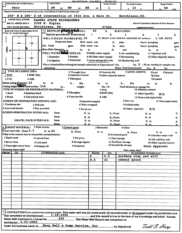
| Owner: Kansas State Fairgrounds | Status: Plugged | ||
| Location: T23S, R5W, Sec. 1, SW SW NE | County: Reno | ||
| Directions: from 25th Ave and Main St: 250' E, 200' S, Hutchinson | |||
| Latitude: 38.0801294 | Longitude: -97.8194171 | Datum NAD 27 | |
| Latitude: 38.0801403 | Longitude: -97.8197441 | Datum NAD 83 | |
| Longitude and latitude calculated by Survey from township-range-section-quarter calls. Only good to within the quarter call accuracy. | |||
| View well on interactive map | |||
| General Info | ||
| Well Depth: 22 ft. | Elevation: ft. | |
| Static Water Level: 16 ft. | Est. Yield: gpm. | |
| Comp. Date: 18-Jan-2002 | Well Use: Domestic, Lawn and Garden | |
| DWR Applic. #: | Other ID: | |
| Driller Info | ||
| Driller: Harp Well & Pump Service, Inc. | License #: 236 | |
| Scanned Form | View scan |
| Casing Info | ||
|
Casing Type:
Diam: in. Casing height above land surface: in | ||
| Grout Info | ||
| Grout used: | From: to ft | |
| Source of Possible Contamination | ||
| Source: | ||
| Direction from well: | Distance: ft | |