|
|
|
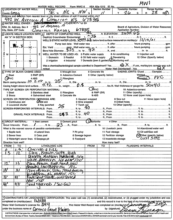
Specific Water Well Detail |
|
|
| Location Info | |||
| Owner: Osborn 66 | Status: Constructed | ||
| Location: T26S, R28W, Sec. 11, SE NE NW | County: Gray | ||
| Directions: 402 W Ave A, Cimarron | |||
| Latitude: 37.8073474 | Longitude: -100.3521536 | Datum NAD 27 | |
| Latitude: 37.8073689 | Longitude: -100.3525763 | Datum NAD 83 | |
| Longitude and latitude calculated by Survey from township-range-section-quarter calls. Only good to within the quarter call accuracy. | |||
| View well on interactive map | |||
| General Info | ||
| Well Depth: 42 ft. | Elevation: 2634.65 ft. | |
| Static Water Level: 35.03 ft. | Est. Yield: gpm. | |
| Comp. Date: 11-Dec-2001 | Well Use: Monitoring well/observation/piezometer | |
| DWR Applic. #: | Other ID: MW 1 | |
| Driller Info | ||
| Driller: Coranco Great Plains, Inc. | License #: 594 | |
| Scanned Form | View scan |
|
Chemical Sample Submitted?:
Water Well disinfected?: | ||
| Casing Info | ||
| Casing Type:
Casing Joints: |
Diam: in. to ft | |
| Casing height above land surface: in
Casing Weight: lbs/ft Wall thickness or gauge no.: | ||
| Screen and Perforation Info | ||
| Screen Type: | Screen Openings: | |
| Screen-perforated intervals | From: ft to ft | |
| Gravel pack intervals | From: ft to ft | |
| Grout Info | ||
| Grout used: | From: to ft | |
| Source of Possible Contamination | ||
| Source: | ||
| Direction from well: | Distance: ft | |
| Lithologic Log
(Log data entered by KGS.) | ||
| From: 0 ft. to 1.5 ft. | Concrete and Fill | |
| From: 1.5 ft. to 12 ft. | Clay, brown, silty, high density, medium plasticity, gray white particles, no odor | |
| From: 12 ft. to 13 ft. | Clay, Brown, Fine sand, low density, low plasticity | |
| From: 13 ft. to 31 ft. | Clay, brown, silty, med density low plasticity, dry, no odor | |
| From: 31 ft. to 41 ft. | Fine sand, black, well sorted odor | |
| From: 41 ft. to 43 ft. | Sand and gravel | |