|
|
|
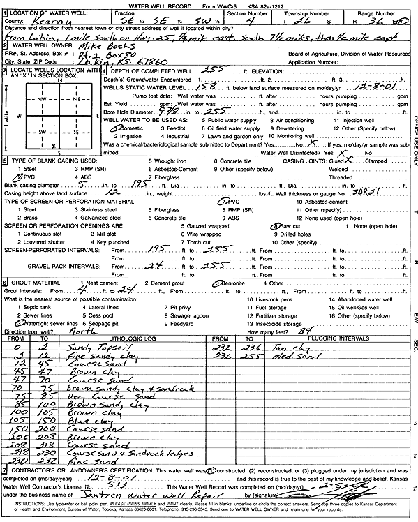
Specific Water Well Detail |
|
|
| Location Info | |||
| Owner: Boehs, Mike | Status: Constructed | ||
| Location: T26S, R36W, Sec. 4, SE SE SW | County: Kearny | ||
| Directions: from Lakin: 1 mi S on Hwy 25, .25 mi E, 7.5 mi S, .5 mi E | |||
| Latitude: 37.8100657 | Longitude: -101.2633659 | Datum NAD 27 | |
| Latitude: 37.8100843 | Longitude: -101.2638152 | Datum NAD 83 | |
| Longitude and latitude calculated by Survey from township-range-section-quarter calls. Only good to within the quarter call accuracy. | |||
| View well on interactive map | |||
| General Info | ||
| Well Depth: 255 ft. | Elevation: ft. | |
| Static Water Level: 158 ft. | Est. Yield: gpm. | |
| Comp. Date: 08-Dec-2001 | Well Use: Domestic | |
| DWR Applic. #: | Other ID: | |
| Driller Info | ||
| Driller: Ed Jantzen Water Well Repair | License #: 533 | |
| Scanned Form | View scan |
|
Chemical Sample Submitted?:
Water Well disinfected?: | ||
| Casing Info | ||
| Casing Type:
Casing Joints: |
Diam: in. to ft | |
| Casing height above land surface: in
Casing Weight: lbs/ft Wall thickness or gauge no.: | ||
| Screen and Perforation Info | ||
| Screen Type: | Screen Openings: | |
| Screen-perforated intervals | From: ft to ft | |
| Gravel pack intervals | From: ft to ft | |
| Grout Info | ||
| Grout used: | From: to ft | |
| Source of Possible Contamination | ||
| Source: | ||
| Direction from well: | Distance: ft | |
| Lithologic Log
(Log data entered by KGS.) | ||
| From: 0 ft. to 2 ft. | sandy top soil | |
| From: 2 ft. to 12 ft. | fine sandy clay | |
| From: 12 ft. to 45 ft. | coarse sand | |
| From: 45 ft. to 47 ft. | brown clay | |
| From: 47 ft. to 70 ft. | coarse sand | |
| From: 70 ft. to 75 ft. | brown sandy clay and sandrock | |
| From: 75 ft. to 85 ft. | very coarse sand | |
| From: 85 ft. to 100 ft. | brown sandy clay | |
| From: 100 ft. to 105 ft. | brown clay | |
| From: 105 ft. to 150 ft. | blue clay | |
| From: 150 ft. to 200 ft. | coarse sand | |
| From: 200 ft. to 208 ft. | brown clay | |
| From: 208 ft. to 218 ft. | coarse sand | |
| From: 218 ft. to 230 ft. | coarse sand and sandrock ledges | |
| From: 230 ft. to 232 ft. | fine sand | |
| From: 232 ft. to 236 ft. | tan clay | |
| From: 236 ft. to 255 ft. | medium sand | |