|
|
|
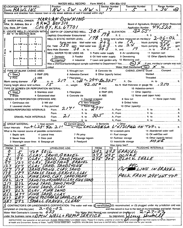
Specific Water Well Detail |
|
|
| Location Info | |||
| Owner: Downing, Harlan | Status: Constructed | ||
| Location: T5S, R34W, Sec. 17, NW SW NW | County: Rawlins | ||
| Directions: | |||
| Latitude: 39.6217516 | Longitude: -101.1681049 | Datum NAD 27 | |
| Latitude: 39.6217519 | Longitude: -101.168541 | Datum NAD 83 | |
| Longitude and latitude calculated by Survey from township-range-section-quarter calls. Only good to within the quarter call accuracy. | |||
| View well on interactive map | |||
| General Info | ||
| Well Depth: 305 ft. | Elevation: 3255 ft. | |
| Static Water Level: 178 ft. | Est. Yield: 350 gpm. | |
| Comp. Date: 06-Feb-2002 | Well Use: Irrigation | |
| DWR Applic. #: 44520 | Other ID: | |
| Links | |
| No Wizard information available. | |
| View info from WIMAS Water Right Data base... | |
| Driller Info | ||
| Driller: DMW Well & Pump Service | License #: 633 | |
| Scanned Form | View scan |
|
Chemical Sample Submitted?:
Water Well disinfected?: | ||
| Casing Info | ||
| Casing Type:
Casing Joints: |
Diam: in. to ft | |
| Casing height above land surface: in
Casing Weight: lbs/ft Wall thickness or gauge no.: | ||
| Screen and Perforation Info | ||
| Screen Type: | Screen Openings: | |
| Screen-perforated intervals | From: ft to ft | |
| Gravel pack intervals | From: ft to ft | |
| Grout Info | ||
| Grout used: | From: to ft | |
| Source of Possible Contamination | ||
| Source: | ||
| Direction from well: | Distance: ft | |
| Lithologic Log
(Log data entered by KGS.) | ||
| From: 0 ft. to 5 ft. | top soil | |
| From: 5 ft. to 56 ft. | clay, sand, gravel | |
| From: 56 ft. to 97 ft. | clay, sand, sandstone | |
| From: 97 ft. to 127 ft. | clay, sandstone, gravel | |
| From: 127 ft. to 157 ft. | clay, sand, sandstone | |
| From: 157 ft. to 178 ft. | sandstone, clay, sand | |
| From: 178 ft. to 187 ft. | coarse sand, gravel, clay | |
| From: 187 ft. to 202 ft. | fine sand, clay, sandstone | |
| From: 202 ft. to 217 ft. | sandstone, hard, clay, fine sand | |
| From: 217 ft. to 232 ft. | fine sand, sandstone | |
| From: 232 ft. to 247 ft. | fine sand, clay | |
| From: 247 ft. to 262 ft. | clay, fine sand | |
| From: 262 ft. to 277 ft. | fine sand, clay | |
| From: 277 ft. to 287 ft. | fine to coarse sand, clay | |
| From: 287 ft. to 292 ft. | small gravel, clean | |
| From: 292 ft. to 293 ft. | gravel | |
| From: 293 ft. to 295 ft. | ochre | |
| From: 295 ft. to 305 ft. | black shale | |