|
|
|
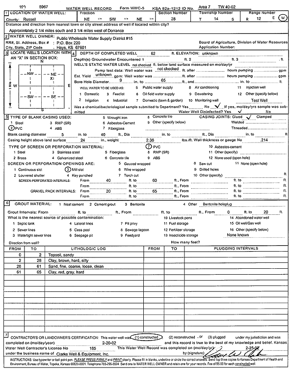
Specific Water Well Detail |
|
|
| Location Info | |||
| Owner: Public Wholesale Water Supply District 15 | Status: Constructed | ||
| Location: T14S, R12W, Sec. 28, NE SW NE | County: Russell | ||
| Directions: from Dorrance: 2.25 mi S, 3.25 mi W | |||
| Latitude: 38.8085327 | Longitude: -98.6563594 | Datum NAD 27 | |
| Latitude: 38.8085438 | Longitude: -98.656712 | Datum NAD 83 | |
| Longitude and latitude calculated by Survey from township-range-section-quarter calls. Only good to within the quarter call accuracy. | |||
| View well on interactive map | |||
| General Info | ||
| Well Depth: 62 ft. | Elevation: ft. | |
| Static Water Level: ft. | Est. Yield: gpm. | |
| Comp. Date: 20-Feb-2002 | Well Use: Test hole/well | |
| DWR Applic. #: 5967 | Other ID: Area 7 TW 40-02 | |
| Driller Info | ||
| Driller: Clarke Well and Equipment, Inc. | License #: 185 | |
| Scanned Form | View scan |
|
Chemical Sample Submitted?:
Water Well disinfected?: | ||
| Casing Info | ||
| Casing Type:
Casing Joints: |
Diam: in. to ft | |
| Casing height above land surface: in
Casing Weight: lbs/ft Wall thickness or gauge no.: | ||
| Screen and Perforation Info | ||
| Screen Type: | Screen Openings: | |
| Screen-perforated intervals | From: ft to ft | |
| Gravel pack intervals | From: ft to ft | |
| Grout Info | ||
| Grout used: | From: to ft | |
| Source of Possible Contamination | ||
| Source: | ||
| Direction from well: | Distance: ft | |
| Lithologic Log
(Log data entered by KGS.) | ||
| From: 0 ft. to 2 ft. | sandy top soil | |
| From: 2 ft. to 28 ft. | silty clay, brown, hard | |
| From: 28 ft. to 61 ft. | fine-coarse sand, loose, clean | |
| From: 61 ft. to 65 ft. | clay, red, gray, hard | |