|
|
|
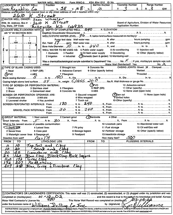
Specific Water Well Detail |
|
|
| Location Info | |||
| Owner: Wheeler, Sean | Status: Constructed | ||
| Location: T3S, R3W, Sec. 10, SE NE | County: Republic | ||
| Directions: 2610 K St, Belleville | |||
| Latitude: 39.8070477 | Longitude: -97.6352584 | Datum NAD 27 | |
| Latitude: 39.8070532 | Longitude: -97.6355778 | Datum NAD 83 | |
| Longitude and latitude calculated by Survey from township-range-section-quarter calls. Only good to within the quarter call accuracy. | |||
| View well on interactive map | |||
| General Info | ||
| Well Depth: 240 ft. | Elevation: ft. | |
| Static Water Level: 96 ft. | Est. Yield: 17 gpm. | |
| Comp. Date: 10-Jan-2002 | Well Use: Domestic, Lawn and Garden | |
| DWR Applic. #: | Other ID: | |
| Driller Info | ||
| Driller: Ron Williams Drilling Co., Inc. | License #: 480 | |
| Scanned Form | View scan |
|
Chemical Sample Submitted?:
Water Well disinfected?: | ||
| Casing Info | ||
| Casing Type:
Casing Joints: |
Diam: in. to ft | |
| Casing height above land surface: in
Casing Weight: lbs/ft Wall thickness or gauge no.: | ||
| Screen and Perforation Info | ||
| Screen Type: | Screen Openings: | |
| Screen-perforated intervals | From: ft to ft | |
| Gravel pack intervals | From: ft to ft | |
| Grout Info | ||
| Grout used: | From: to ft | |
| Source of Possible Contamination | ||
| Source: | ||
| Direction from well: | Distance: ft | |
| Lithologic Log
(Log data entered by KGS.) | ||
| From: 0 ft. to 10 ft. | top soil and clay | |
| From: 10 ft. to 20 ft. | sand and clay | |
| From: 20 ft. to 25 ft. | limestone and clay | |
| From: 25 ft. to 160 ft. | blue clay, black clay, and rock layers | |
| From: 160 ft. to 172 ft. | gray clay | |
| From: 172 ft. to 207 ft. | sandstone | |
| From: 207 ft. to 240 ft. | blue, gray, and firestone clay | |