|
|
|
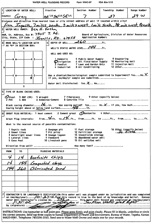
Specific Water Well Detail |
|
|
| Location Info | |||
| Owner: Koehn, Ben H | Status: Plugged | ||
| Location: T27S, R29W, Sec. 7, NE SW SE | County: Gray | ||
| Directions: from Ingalls: 7 mi S, 3 mi W, 1 mi S, .38 mi W, .25 mi N | |||
| Latitude: 37.7106627 | Longitude: -100.5300833 | Datum NAD 27 | |
| Latitude: 37.7106857 | Longitude: -100.5305129 | Datum NAD 83 | |
| Longitude and latitude calculated by Survey from township-range-section-quarter calls. Only good to within the quarter call accuracy. | |||
| View well on interactive map | |||
| General Info | ||
| Well Depth: 260 ft. | Elevation: ft. | |
| Static Water Level: 144 ft. | Est. Yield: gpm. | |
| Comp. Date: 27-Oct-2001 | Well Use: Irrigation | |
| DWR Applic. #: | Other ID: | |
| Links | |
| View info from Wizard Water Level Data base... | |
| View info from WIMAS Water Right Data base... | |
| Driller Info | ||
| Driller: Ed Jantzen Water Well Repair | License #: 533 | |
| Scanned Form | View scan |
| Casing Info | ||
|
Casing Type:
Diam: in. Casing height above land surface: in | ||
| Grout Info | ||
| Grout used: | From: to ft | |
| Source of Possible Contamination | ||
| Source: | ||
| Direction from well: | Distance: ft | |