|
|
|
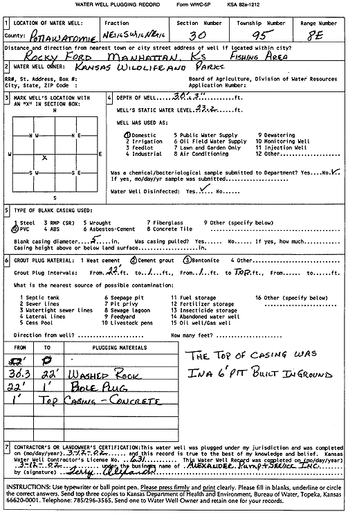
Specific Water Well Detail |
|
|
| Location Info | |||
| Owner: Kansas Dept. of Wildlife and Parks | Status: Plugged | ||
| Location: T9S, R8E, Sec. 30, NE SW NE | County: Pottawatomie | ||
| Directions: Rocky Ford, Fishing Area, Manhattan | |||
| Latitude: 39.2430224 | Longitude: -96.5670949 | Datum NAD 27 | |
| Latitude: 39.2430188 | Longitude: -96.5673755 | Datum NAD 83 | |
| Longitude and latitude calculated by Survey from township-range-section-quarter calls. Only good to within the quarter call accuracy. | |||
| View well on interactive map | |||
| General Info | ||
| Well Depth: 30.25 ft. | Elevation: ft. | |
| Static Water Level: 23.2 ft. | Est. Yield: gpm. | |
| Comp. Date: 12-Mar-2002 | Well Use: Domestic | |
| DWR Applic. #: | Other ID: | |
| Driller Info | ||
| Driller: Terry Alexander Pump & Service | License #: 631 | |
| Scanned Form | View scan |
| Casing Info | ||
|
Casing Type:
Diam: in. Casing height above land surface: in | ||
| Grout Info | ||
| Grout used: | From: to ft | |
| Source of Possible Contamination | ||
| Source: | ||
| Direction from well: | Distance: ft | |