|
|
|
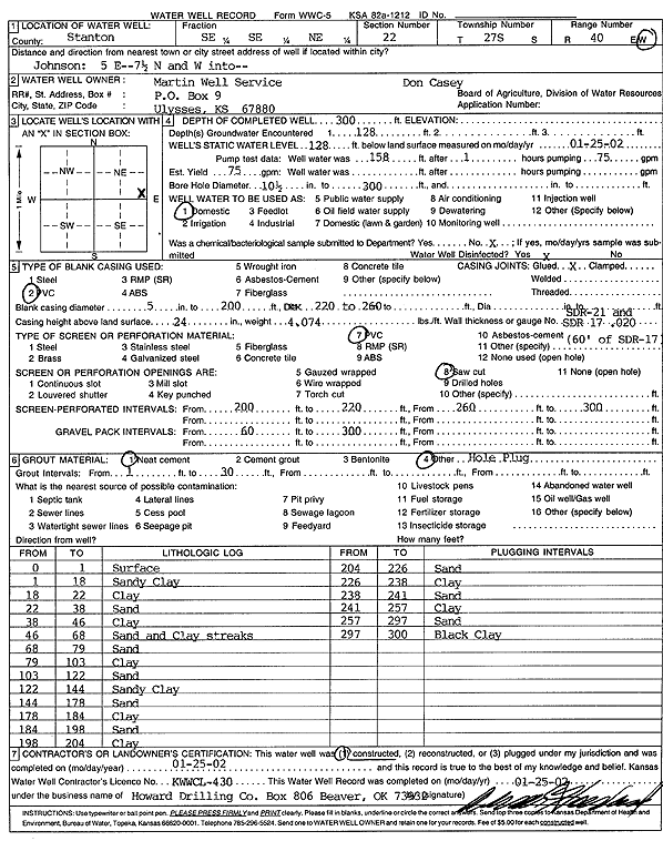
Specific Water Well Detail |
|
|
| Location Info | |||
| Owner: Martin Well Services c/o Don Casey | Status: Constructed | ||
| Location: T27S, R40W, Sec. 22, SE SE NE | County: Stanton | ||
| Directions: from Johnson: 5 mi E, 7.5 mi N, W into site | |||
| Latitude: 37.68703 | Longitude: -101.6723792 | Datum NAD 27 | |
| Latitude: 37.687045 | Longitude: -101.6728287 | Datum NAD 83 | |
| Longitude and latitude calculated by Survey from township-range-section-quarter calls. Only good to within the quarter call accuracy. | |||
| View well on interactive map | |||
| General Info | ||
| Well Depth: 300 ft. | Elevation: ft. | |
| Static Water Level: 128 ft. | Est. Yield: 75 gpm. | |
| Comp. Date: 25-Jan-2002 | Well Use: Domestic | |
| DWR Applic. #: | Other ID: | |
| Driller Info | ||
| Driller: Howard Drilling Company AG, LLC | License #: 430 | |
| Scanned Form | View scan |
|
Chemical Sample Submitted?:
Water Well disinfected?: | ||
| Casing Info | ||
| Casing Type:
Casing Joints: |
Diam: in. to ft | |
| Casing height above land surface: in
Casing Weight: lbs/ft Wall thickness or gauge no.: | ||
| Screen and Perforation Info | ||
| Screen Type: | Screen Openings: | |
| Screen-perforated intervals | From: ft to ft | |
| Gravel pack intervals | From: ft to ft | |
| Grout Info | ||
| Grout used: | From: to ft | |
| Source of Possible Contamination | ||
| Source: | ||
| Direction from well: | Distance: ft | |
| Lithologic Log
(Log data entered by KGS.) | ||
| From: 0 ft. to 1 ft. | surface | |
| From: 1 ft. to 18 ft. | sandy clay | |
| From: 18 ft. to 22 ft. | clay | |
| From: 22 ft. to 38 ft. | sand | |
| From: 38 ft. to 46 ft. | clay | |
| From: 46 ft. to 68 ft. | sand and clay streaks | |
| From: 68 ft. to 79 ft. | sand | |
| From: 79 ft. to 103 ft. | clay | |
| From: 103 ft. to 122 ft. | sand | |
| From: 122 ft. to 144 ft. | sandy clay | |
| From: 144 ft. to 178 ft. | sand | |
| From: 178 ft. to 184 ft. | clay | |
| From: 184 ft. to 198 ft. | sand | |
| From: 198 ft. to 204 ft. | clay | |
| From: 204 ft. to 226 ft. | sand | |
| From: 226 ft. to 238 ft. | clay | |
| From: 238 ft. to 241 ft. | sand | |
| From: 241 ft. to 257 ft. | clay | |
| From: 257 ft. to 297 ft. | sand | |
| From: 297 ft. to 300 ft. | black clay | |